Fraud Blocker Skip to main content

Home > Asia > Vietnam > Maps
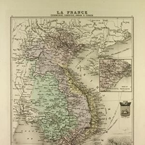
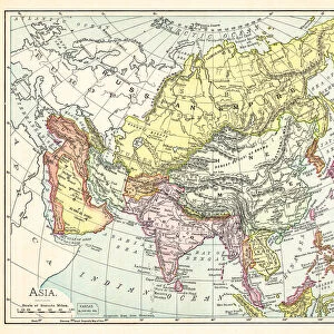
Map of Asia 1877

Map of Asia 1877


Photo Prints
Jigsaw Puzzles
Poster Prints
Canvas Prints
Fine Art Prints
Metal Prints
Cards
Home Decor


We accept all major credit cards

Fine Art Storehouse

Wall Art and Photo Gifts from Fine Art Storehouse

Map of Asia 1877

Warrens Common School Geography 1877

Unleash your creativity and transform your space into a visual masterpiece!

THEPALMER

Media ID 14824559

© This content is subject to copyright

China East Asia India Indochina Japan Vietnam


FEATURES IN THESE COLLECTIONS

> Asia > China > Maps

> Asia > Cyprus > Maps

> Asia > India > Maps

> Asia > Japan > Maps

> Asia > Vietnam > Maps

> Fine Art Storehouse > Map > Historical Maps

> Fine Art Storehouse > Map

> Maps and Charts > Early Maps

> Maps and Charts > India


EDITORS COMMENTS
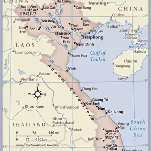
This print titled "Map of Asia 1877" takes us on a journey back in time, immersing us in the rich historical tapestry of the continent. A relic from Warrens Common School Geography, published in 1877, this map offers a glimpse into how Asia was perceived over a century ago. The intricate details and vibrant colors bring to life the diverse landscapes and cultural nuances that define this vast region. From China's majestic Great Wall to India's sprawling Gangetic plains, each country is meticulously outlined with precision and care. The map also highlights Indochina's lush jungles, Japan's archipelago stretching across the Pacific Ocean, and Vietnam's winding rivers. As we gaze upon this piece by THEPALMER from Fine Art Storehouse, our minds wander through time as we contemplate the geopolitical shifts that have shaped Asia since its creation. It serves as a reminder of how borders have evolved and nations have risen or fallen throughout history. Beyond its educational value, this print possesses an aesthetic allure that captivates viewers. Its vintage charm adds character to any space it graces—be it a study room or an art gallery wall—inviting contemplation about our place within the ever-changing world. "The Map of Asia 1877" transports us not only geographically but also emotionally—a visual testament to humanity's curiosity for exploration and understanding.

MADE IN AUSTRALIA
Safe Shipping with 30 Day Money Back Guarantee

FREE PERSONALISATION*
We are proud to offer a range of customisation features including Personalised Captions, Color Filters and Picture Zoom Tools

SECURE PAYMENTS
We happily accept a wide range of payment options so you can pay for the things you need in the way that is most convenient for you

* Options may vary by product and licensing agreement. Zoomed Pictures can be adjusted in the Cart.


redeem
Beautiful Photo Prints and Gifts
image
Professionally Printed
thumb_up
Professional quality finish
diamond
Made with high-grade materials
inventory_2
Carefully packed to aid safe arrival


Related Images


Harbour, Malaga, Spain, By Edward T. Compton (1849-1921) From The Picturesque Mediterranean Circa 1890
Gardener earthing up potato plants
Firemen attemting to control heather moor burning on shooting estate which had started to blaze out of control
Monsal Head viaduct and footpath sign in spring, Peak District National Park, Derbyshire, England, United Kingdom, Europe
View of rock formations in upland habitat at sunset, Winterhoekberge, Western Cape, South Africa, February
Map of Vietnam, Cambodia, Thailand, Laos, 1896
Map of South America (early 19th century steel engraving)
Map of Assyria illustrating the biblical Patriarchal Age
Map of Massachusetts 1877
Map of Asia 1895
Map of Asia 1895
Assumption of the Virgin, 1516-1518 (1870). Artist: Roland Brunier
The Stroboglow, 1938

+

Shipping

+

Choices

+

Reviews

+

Guaranteed


Related Collections


Early Maps
Early Maps
Browse 24,907 Prints
Map
Map
Browse 9,856 Prints
Maps
Maps
Browse 628 Prints
Maps
Maps
Browse 628 Prints
Maps
Maps
Browse 790 Prints
Maps
Maps
Browse 377 Prints
Maps
Maps
Browse 60 Prints
India
India
Browse 542 Prints
Historical Maps
Historical Maps
Browse 3,307 Prints