Home > Maps and Charts > Early Maps
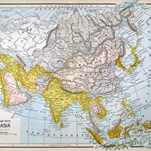
Map of Asia 19th century

![]()
Wall Art and Photo Gifts from Fine Art Storehouse
Map of Asia 19th century
Vintage map of Asia in the 19th century
Unleash your creativity and transform your space into a visual masterpiece!
duncan1890
Media ID 20172649
© duncan1890
Asia Pac Middle East North Pacific Ocean
FEATURES IN THESE COLLECTIONS
> Asia
> Related Images
> Fine Art Storehouse
> Map
> Historical Maps
> Maps and Charts
> Early Maps
EDITORS COMMENTS
This print takes us on a journey back in time to the 19th century, where we explore the intricate details of a vintage map of Asia. Created by Duncan1890 and available at Fine Art Storehouse, this piece showcases the artistry and precision of cartography during that era. The map encompasses vast regions, from Asia Pacific to North Pacific Ocean, Middle East to Persian Gulf. Its rich colors and delicate lines draw our attention towards every corner, revealing countless cities, rivers, mountains, and borders. As we gaze upon this historical artifact, we can't help but imagine the explorers who relied on such maps for their adventures across these lands. The level of craftsmanship evident in this print is truly remarkable; it serves as a testament to the dedication and skill required to create accurate representations of geographical landscapes before modern technology revolutionized cartography. Each stroke tells a story - stories of trade routes connecting distant civilizations or tales of conquests shaping empires. Whether you are an avid history enthusiast or simply appreciate fine art with cultural significance, this vintage map will undoubtedly transport you into an era long gone. Hang it proudly in your home or office space as a conversation starter or use it as an educational tool for young minds eager to learn about our world's past. Duncan1890's Map of Asia offers not only aesthetic pleasure but also invites us to reflect upon how far humanity has come in understanding and navigating our planet throughout centuries.
MADE IN AUSTRALIA
Safe Shipping with 30 Day Money Back Guarantee
FREE PERSONALISATION*
We are proud to offer a range of customisation features including Personalised Captions, Color Filters and Picture Zoom Tools
SECURE PAYMENTS
We happily accept a wide range of payment options so you can pay for the things you need in the way that is most convenient for you
* Options may vary by product and licensing agreement. Zoomed Pictures can be adjusted in the Cart.