Home > North America > United States of America > New York > New York > Maps
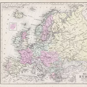
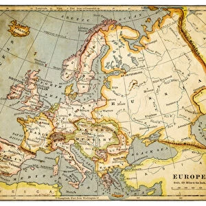
Map of Europe 1877

![]()
Wall Art and Photo Gifts from Fine Art Storehouse
Map of Europe 1877
The Eclectic Elementary Geography by Wilson & Hinkle / Cincinnati -New York 1881
Unleash your creativity and transform your space into a visual masterpiece!
THEPALMER
Media ID 15133658
© This content is subject to copyright
FEATURES IN THESE COLLECTIONS
> Europe
> Related Images
> Fine Art Storehouse
> Map
> Historical Maps
> Maps and Charts
> Early Maps
> North America
> United States of America
> New York
> New York
> Maps
EDITORS COMMENTS
This print showcases a historical gem, the "Map of Europe 1877" from "The Eclectic Elementary Geography" by Wilson & Hinkle. Published in Cincinnati and New York in 1881, this remarkable piece takes us back to a time when cartography was an art form in itself. The map's intricate details and vibrant colors transport us to the European continent as it stood over a century ago. As we gaze upon this vintage masterpiece, we are reminded of the immense changes that have shaped Europe since then. Each country is meticulously outlined, revealing borders that have shifted with time and history. From the vast Russian Empire stretching across Eastern Europe to the powerful British Isles reigning supreme over their colonies, every nation tells its own story within these lines. Beyond its historical significance, this print also serves as a testament to human curiosity and exploration. It reminds us of our innate desire to understand our world better and navigate through its complexities. As we admire each carefully labeled city and river on this map, we can almost feel ourselves embarking on an imaginary journey through time. "The Map of Europe 1877" by THEPALMER offers not only aesthetic pleasure but also invites contemplation about how far we've come since those days depicted on paper. This artwork captures both our fascination with history and our appreciation for the beauty found within maps themselves – guiding tools that connect us all regardless of time or place.
MADE IN AUSTRALIA
Safe Shipping with 30 Day Money Back Guarantee
FREE PERSONALISATION*
We are proud to offer a range of customisation features including Personalised Captions, Color Filters and Picture Zoom Tools
SECURE PAYMENTS
We happily accept a wide range of payment options so you can pay for the things you need in the way that is most convenient for you
* Options may vary by product and licensing agreement. Zoomed Pictures can be adjusted in the Cart.