Home > Maps and Charts > Early Maps
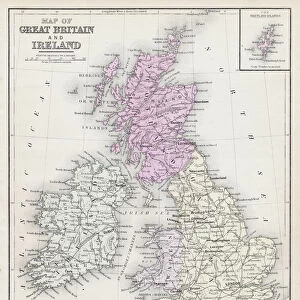
Map of Great Britain 1900

![]()
Wall Art and Photo Gifts from Fine Art Storehouse
Map of Great Britain 1900
Meyers hand-Atlas Leipzig und Wien Verlag des Bibliographischen Instituts 1900
Unleash your creativity and transform your space into a visual masterpiece!
THEPALMER
Media ID 18106863
© 2014 Roberto Adrian Photography
FEATURES IN THESE COLLECTIONS
> Fine Art Storehouse
> Map
> Historical Maps
> Maps and Charts
> Early Maps
EDITORS COMMENTS
In this photo print, THEPALMER takes us on a journey back in time to the year 1900 with their stunning reproduction of the "Map of Great Britain". This particular map, originally published in Meyers hand-Atlas Leipzig und Wien Verlag des Bibliographischen Instituts, offers a fascinating glimpse into the intricate details and cartographic artistry of that era. As we gaze upon this vintage treasure, our eyes are immediately drawn to the rich colors and meticulous craftsmanship. The delicate lines trace every contour of Great Britain's landscape, showcasing its diverse topography from rolling hills to majestic mountains. Each city and town is meticulously labeled, allowing us to envision bustling streets and historic landmarks frozen in time. The Map of Great Britain serves as more than just a geographical representation; it is an invaluable historical artifact. It invites us to explore how boundaries have shifted over time and marvel at the evolution of transportation networks that once connected these regions. Beyond its educational value, this print also exudes a sense of nostalgia for simpler times when maps were cherished objects used for exploration or planning grand adventures. THEPALMER's expertly reproduced print allows us to appreciate not only the beauty but also the significance of this piece within our collective history. Whether displayed in an office or home setting, it sparks curiosity and prompts conversations about bygone eras while adding a touch of timeless elegance to any space.
MADE IN AUSTRALIA
Safe Shipping with 30 Day Money Back Guarantee
FREE PERSONALISATION*
We are proud to offer a range of customisation features including Personalised Captions, Color Filters and Picture Zoom Tools
SECURE PAYMENTS
We happily accept a wide range of payment options so you can pay for the things you need in the way that is most convenient for you
* Options may vary by product and licensing agreement. Zoomed Pictures can be adjusted in the Cart.