Home > North America > United States of America > New York > New York > Maps
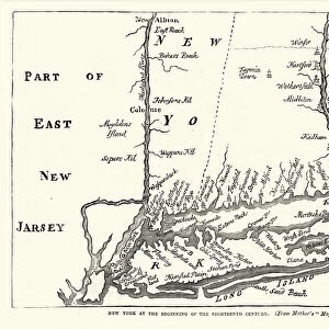
Map of New York 1900

![]()
Wall Art and Photo Gifts from Fine Art Storehouse
Map of New York 1900
Meyers hand-Atlas Leipzig und Wien Verlag des Bibliographischen Instituts 1900
Unleash your creativity and transform your space into a visual masterpiece!
THEPALMER
Media ID 18106931
© 2014 Roberto Adrian Photography
FEATURES IN THESE COLLECTIONS
> Fine Art Storehouse
> Map
> Historical Maps
> Maps and Charts
> Early Maps
> North America
> United States of America
> New York
> New York
> Maps
EDITORS COMMENTS
In this print titled "Map of New York 1900". THEPALMER takes us on a journey back in time to the bustling streets and iconic landmarks of turn-of-the-century New York City. This meticulously detailed map, originally published in Meyers hand-Atlas Leipzig und Wien Verlag des Bibliographischen Instituts in 1900, offers a fascinating glimpse into the city's rich history. As we gaze upon this vintage piece, our eyes are immediately drawn to the intricate network of streets and avenues that crisscross Manhattan Island. The map showcases the city's vibrant neighborhoods, from the elegant brownstones of Upper East Side to the lively markets of Lower Manhattan. Skyscrapers begin to emerge amidst rows of charming buildings, hinting at the architectural marvels that would soon shape New York's famous skyline. The artist skillfully captures every minute detail with remarkable precision - from Central Park's winding paths and tranquil lakes to Brooklyn Bridge majestically spanning across East River. Each borough is clearly delineated, allowing us to trace our fingers along its borders and imagine what life was like for New Yorkers over a century ago. "The Map of New York 1900" serves as both an artistic masterpiece and a historical document. It invites viewers to immerse themselves in an era long gone but not forgotten – when horse-drawn carriages traversed cobblestone streets and street vendors peddled their wares beneath gas-lit lampposts. This print is sure to
MADE IN AUSTRALIA
Safe Shipping with 30 Day Money Back Guarantee
FREE PERSONALISATION*
We are proud to offer a range of customisation features including Personalised Captions, Color Filters and Picture Zoom Tools
SECURE PAYMENTS
We happily accept a wide range of payment options so you can pay for the things you need in the way that is most convenient for you
* Options may vary by product and licensing agreement. Zoomed Pictures can be adjusted in the Cart.