Home > North America > United States of America > New York > New York > Maps
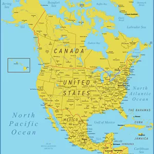
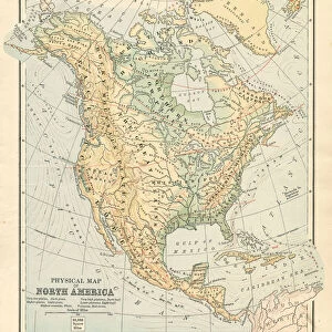
Map of North America 1899

![]()
Wall Art and Photo Gifts from Fine Art Storehouse
Map of North America 1899
Maurys Geographical Series Manual of Geography - New York 1899
Unleash your creativity and transform your space into a visual masterpiece!
THEPALMER
Media ID 20114761
© A 2014 Roberto Adrian Photography
FEATURES IN THESE COLLECTIONS
> Fine Art Storehouse
> Map
> Historical Maps
> Maps and Charts
> Early Maps
> North America
> United States of America
> New York
> New York
> Maps
EDITORS COMMENTS
This print titled "Map of North America 1899" takes us back in time to the late 19th century, offering a glimpse into the intricate world of cartography. The map, part of Maurys Geographical Series Manual of Geography from New York in 1899, showcases the meticulous craftsmanship and attention to detail that characterized this era's maps. As we gaze upon this piece by THEPALMER from Fine Art Storehouse, we are transported to an age when exploration and discovery were at their peak. The map unfolds before our eyes like a treasure trove of knowledge, revealing the vast expanse of North America with its diverse landscapes and geographical features. From the rugged mountains that stretch along the western coast to the expansive plains that dominate much of central United States and Canada, every contour is meticulously depicted. Rivers meander across the continent like lifelines connecting different regions while cities and towns dotting the landscape indicate human settlements amidst nature's grandeur. The sepia-toned hues lend an air of nostalgia to this historical artifact, evoking a sense of wonderment for those who appreciate both artistry and history. This print serves as a testament to mankind's insatiable curiosity about our planet and its inhabitants. Whether displayed in a study or living room, this Map of North America 1899 invites us on an enchanting journey through time—a reminder that even within our modern world lies a rich tapestry woven by explorers who sought to understand their surroundings better.
MADE IN AUSTRALIA
Safe Shipping with 30 Day Money Back Guarantee
FREE PERSONALISATION*
We are proud to offer a range of customisation features including Personalised Captions, Color Filters and Picture Zoom Tools
SECURE PAYMENTS
We happily accept a wide range of payment options so you can pay for the things you need in the way that is most convenient for you
* Options may vary by product and licensing agreement. Zoomed Pictures can be adjusted in the Cart.