Home > Maps and Charts > Americas
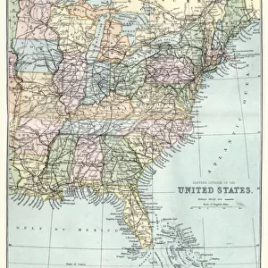
Map of North America 1900

![]()
Wall Art and Photo Gifts from Fine Art Storehouse
Map of North America 1900
Meyers hand-Atlas Leipzig und Wien Verlag des Bibliographischen Instituts 1900
Unleash your creativity and transform your space into a visual masterpiece!
THEPALMER
Media ID 18106943
© 2014 Roberto Adrian Photography
FEATURES IN THESE COLLECTIONS
> Fine Art Storehouse
> Map
> Historical Maps
> Maps and Charts
> Early Maps
> North America
> Related Images
EDITORS COMMENTS
In this print titled "Map of North America 1900" we are transported back in time to the turn of the century. The image, sourced from Meyers hand-Atlas Leipzig und Wien Verlag des Bibliographischen Instituts 1900, offers a glimpse into the intricate cartography and artistic craftsmanship of that era. The map itself is a testament to both scientific accuracy and aesthetic beauty. With its meticulous detailing, it showcases the vast expanse of North America as it was understood at that time. From the rugged mountains ranges to sprawling rivers and expansive coastlines, every feature is delicately illustrated with precision. As we explore this vintage map, our eyes are drawn to various geographical landmarks such as the majestic Rocky Mountains stretching across western Canada and United States or the mighty Mississippi River meandering through countless states. We can also spot major cities like New York City on the eastern seaboard or San Francisco nestled along California's coastline. Beyond its informational value, this particular print possesses an undeniable charm due to its age. The slightly faded colors and aged paper lend a nostalgic aura that transports us back in time. It serves as a reminder of how much our understanding of geography has evolved over decades. "The Map of North America 1900" by THEPALMER captures not only historical significance but also evokes a sense of wonderment for those who appreciate artistry combined with exploration. Whether displayed in homes or offices, it invites viewers on an enchanting journey through space and time while celebrating both
MADE IN AUSTRALIA
Safe Shipping with 30 Day Money Back Guarantee
FREE PERSONALISATION*
We are proud to offer a range of customisation features including Personalised Captions, Color Filters and Picture Zoom Tools
SECURE PAYMENTS
We happily accept a wide range of payment options so you can pay for the things you need in the way that is most convenient for you
* Options may vary by product and licensing agreement. Zoomed Pictures can be adjusted in the Cart.