Home > Asia > Israel > Jerusalem Heritage Sites > Old City of Jerusalem and its Walls
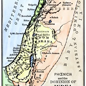
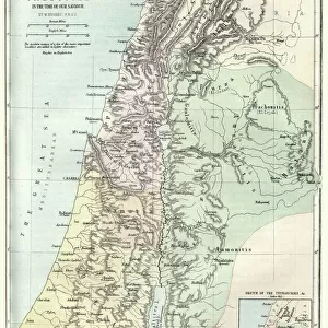
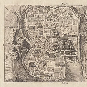
Map of Palestine

![]()
Wall Art and Photo Gifts from Fine Art Storehouse
Map of Palestine
Illustration of a map of Palestine
Unleash your creativity and transform your space into a visual masterpiece!
Nastasic
Media ID 13750441
© This content is subject to copyright
1890 1899 1896 Bible Canaan Valley Coastal Feature Dead Sea Galillee Indigenous Culture Israel Jerusalem Jordan Middle East Judaism Lake Tiberius Lebanon Country Mediterranean Sea Middle East Old Testament Palestine Palestinian Religious Symbol Serbia Topography Golan Heights Number 12 Palestinian Territories
FEATURES IN THESE COLLECTIONS
> Asia
> Israel
> Jerusalem Heritage Sites
> Old City of Jerusalem and its Walls
> Asia
> Palestine
> Jerusalem
> Europe
> Germany
> Lakes
> Related Images
> Fine Art Storehouse
> Map
> Historical Maps
> Fine Art Storehouse
> World Religion
EDITORS COMMENTS
This print showcases a meticulously detailed "Map of Palestine" from 1896, expertly illustrated by Nastasic. The vertical composition allows for an immersive exploration of the Palestinian territories, revealing its rich history and cultural significance. From the ancient Canaan Valley to the enchanting Galilee region, this map takes us on a journey through time. The engraving technique used in this antique piece beautifully captures every topographical feature and coastal detail along the Mediterranean Sea. Jerusalem, with its religious symbolism deeply rooted in Judaism and Christianity, stands prominently at the heart of this map. Additionally, significant landmarks such as Lake Tiberius (also known as the Sea of Galilee) and the Dead Sea are highlighted. As we delve into this historical artifact, it becomes evident that it not only serves as a geographical guide but also offers insights into indigenous cultures and ancient civilizations that once thrived within these lands. Capital cities are marked alongside biblical references from both the Old Testament and New Testament. Nastasic's illustration masterfully combines artistry with cartography to create a visually striking representation of Palestine's past. This print is not just an exquisite decorative piece; it is a testament to our fascination with history and our desire to understand how landscapes have shaped human civilization throughout time.
MADE IN AUSTRALIA
Safe Shipping with 30 Day Money Back Guarantee
FREE PERSONALISATION*
We are proud to offer a range of customisation features including Personalised Captions, Color Filters and Picture Zoom Tools
SECURE PAYMENTS
We happily accept a wide range of payment options so you can pay for the things you need in the way that is most convenient for you
* Options may vary by product and licensing agreement. Zoomed Pictures can be adjusted in the Cart.