Home > North America > United States of America > Pennsylvania > Pittsburgh
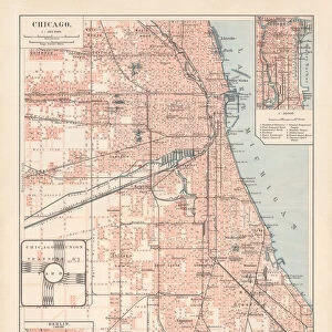
Map of Philadelphia 1898

![]()
Wall Art and Photo Gifts from Fine Art Storehouse
Map of Philadelphia 1898
Antique illustration engraving of a Map of Philadelphia 1898
Unleash your creativity and transform your space into a visual masterpiece!
Nastasic
Media ID 15489963
© Nikola Nastasic
Cartographer North America Pennsylvania Philadelphia Pennsylvania Pittsburgh Plan Planning Urban Scene Obsolete
FEATURES IN THESE COLLECTIONS
> Fine Art Storehouse
> Map
> Historical Maps
> Fine Art Storehouse
> Map
> USA Maps
> Maps and Charts
> Early Maps
> North America
> United States of America
> Maps
> North America
> United States of America
> Pennsylvania
> Philadelphia
> North America
> United States of America
> Pennsylvania
> Pittsburgh
EDITORS COMMENTS
This print showcases an exquisite antique illustration engraving of a Map of Philadelphia from the year 1898. A true testament to the artistry and precision of cartography, this piece takes us back in time to explore the urban scene of one of America's most historic cities. The intricate details captured in this engraved image offer a glimpse into a bygone era, where planning and mapping were meticulously executed by skilled cartographers. The map itself is a fascinating blend of nostalgia and historical significance. It highlights Philadelphia as the capital city of Pennsylvania, proudly representing its importance within North America during that period. As we delve into this old-world treasure, we are transported through streets lined with architectural marvels, bustling neighborhoods brimming with life, and landmarks that have stood the test of time. While gazing at this remarkable piece, it becomes evident how much our cities have evolved over the years. This obsolete representation serves as both a reminder and celebration of our rich history – reminding us to appreciate our roots while embracing progress. Nastasic's masterful capture allows us to admire every intricate detail etched onto this vintage map print. Whether you're a history enthusiast or simply captivated by beautiful works of art, this enchanting engraving will undoubtedly add charm and character to any space it graces.
MADE IN AUSTRALIA
Safe Shipping with 30 Day Money Back Guarantee
FREE PERSONALISATION*
We are proud to offer a range of customisation features including Personalised Captions, Color Filters and Picture Zoom Tools
SECURE PAYMENTS
We happily accept a wide range of payment options so you can pay for the things you need in the way that is most convenient for you
* Options may vary by product and licensing agreement. Zoomed Pictures can be adjusted in the Cart.