Home > Europe > Belarus > Maps
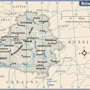
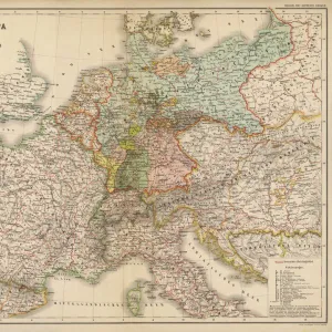
Map of Poland and Western Russia (Belarus), lithograph, published 1897
, lithograph, published 1897")
![]()
Wall Art and Photo Gifts from Fine Art Storehouse
Map of Poland and Western Russia (Belarus), lithograph, published 1897
Historical topographic map of Poland and Western Russia (Belarus). Lithograph, published in 1897
Unleash your creativity and transform your space into a visual masterpiece!
ZU_09
Media ID 18292209
FEATURES IN THESE COLLECTIONS
> Fine Art Storehouse
> Map
> Historical Maps
> Maps and Charts
> Early Maps
EDITORS COMMENTS
This lithograph, titled "Map of Poland and Western Russia (Belarus)" takes us on a journey back in time to the year 1897. A remarkable piece of historical topographic art, it offers a glimpse into the intricate cartography of Eastern Europe during that era. The print showcases the meticulous craftsmanship and attention to detail employed by ZU_09, the talented artist behind this masterpiece. The map itself is an exquisite representation of Poland and Western Russia (Belarus), capturing their geographical features with astonishing accuracy. Every contour, river, mountain range, and city is meticulously depicted, allowing viewers to immerse themselves in these lands as they were over a century ago. As we gaze upon this lithograph, we are transported to a different time - one where borders may have shifted but the beauty of these landscapes remains eternal. It serves as both an educational tool for historians and geographers alike while also appealing to those with an appreciation for fine art. Whether displayed in a study or adorning the walls of a history enthusiast's home, this print stands as a testament to human curiosity and our desire to explore beyond our own horizons. It invites us to reflect on how much has changed since its creation while reminding us that some things endure through time - like our fascination with maps that tell stories about places long gone yet forever etched in memory.
MADE IN AUSTRALIA
Safe Shipping with 30 Day Money Back Guarantee
FREE PERSONALISATION*
We are proud to offer a range of customisation features including Personalised Captions, Color Filters and Picture Zoom Tools
SECURE PAYMENTS
We happily accept a wide range of payment options so you can pay for the things you need in the way that is most convenient for you
* Options may vary by product and licensing agreement. Zoomed Pictures can be adjusted in the Cart.