Home > Arts > Landscape paintings > Waterfall and river artworks > River artworks
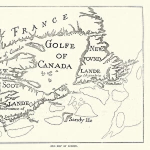
Map of the St Lawrence river, 18th Century

![]()
Wall Art and Photo Gifts from Fine Art Storehouse
Map of the St Lawrence river, 18th Century
Vintage engraving of a Map of the St Lawrence river, 18th Century
Unleash your creativity and transform your space into a visual masterpiece!
duncan1890
Media ID 18563422
© of Duncan P Walker
18th Century 18th Century Style Canada
FEATURES IN THESE COLLECTIONS
> Arts
> Landscape paintings
> Waterfall and river artworks
> River artworks
> Fine Art Storehouse
> Map
> Historical Maps
> Maps and Charts
> Early Maps
> North America
> Canada
> Maps
EDITORS COMMENTS
This vintage engraving takes us back to the 18th century, offering a glimpse into the intricate details of a map showcasing the majestic St Lawrence River. The black and white aesthetic adds an air of nostalgia and authenticity to this antique print, allowing us to appreciate its historical significance. The St Lawrence River, stretching across Canada, has long been an essential waterway for trade and exploration. This meticulously crafted map beautifully captures its meandering path through various provinces and territories. Every curve and bend is delicately etched onto the paper, highlighting key landmarks along its course. As we examine this piece closely, we are transported back in time when explorers braved these waters in search of new frontiers. The 18th-century style evokes a sense of adventure as we imagine sailors navigating their ships along this vital route. Duncan1890's attention to detail truly shines through in this artwork. Each stroke tells a story of discovery and perseverance that shaped Canada's history. Whether you're a history enthusiast or simply captivated by the beauty of cartography, this print is sure to ignite your imagination. Displaying this exquisite piece on your wall will not only add elegance but also serve as a conversation starter for guests who share your appreciation for artistry from bygone eras. Let yourself be transported back in time with this remarkable depiction of the St Lawrence River – an enduring symbol of exploration and connection throughout centuries past.
MADE IN AUSTRALIA
Safe Shipping with 30 Day Money Back Guarantee
FREE PERSONALISATION*
We are proud to offer a range of customisation features including Personalised Captions, Color Filters and Picture Zoom Tools
SECURE PAYMENTS
We happily accept a wide range of payment options so you can pay for the things you need in the way that is most convenient for you
* Options may vary by product and licensing agreement. Zoomed Pictures can be adjusted in the Cart.