Home > Oceania > Australia > Maps
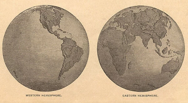
Old, Map of Eastern and Western Hemispheres, From 1875
![]()

Wall Art and Photo Gifts from Fine Art Storehouse
Old, Map of Eastern and Western Hemispheres, From 1875
Old black and white illustration of the Eastern Hemisphere and the Western Hemisphere, from the 1800 s
Unleash your creativity and transform your space into a visual masterpiece!
ideabug
Media ID 14777509
© ideabug
Arctic Ocean Atlantic Ocean Australia Chart Circle Continent Document East Eastern Hemisphere Ephemera Hemisphere Historical Document Image Created 1870 1879 Indian Ocean Intricacy Island New World North America Old World Outline Pacific Ocean Peninsula Sepia Toned South America Stained The Americas Topographic Map Topography West Western Hemisphere World Map 1875 Image Created 19th Century Obsolete
FEATURES IN THESE COLLECTIONS
> Africa
> Related Images
> Asia
> Related Images
> Europe
> Related Images
> Fine Art Storehouse
> Map
> Historical Maps
> Maps and Charts
> Early Maps
> Maps and Charts
> World
> North America
> Related Images
EDITORS COMMENTS
This print takes us back to the 19th century, offering a glimpse into the world as it was in 1875. The image showcases an old map of the Eastern and Western Hemispheres, meticulously illustrated with intricate details that highlight its historical significance. The sepia-toned illustration reveals a stained document, adding to its antique charm. As we explore this topographic map, we can observe the continents of Asia, Europe, Africa, North America, South America, Australia, and even Antarctica. The surrounding bodies of water - Pacific Ocean, Indian Ocean, Atlantic Ocean, Arctic Ocean - are also depicted with great precision. This piece serves as both an obsolete artifact and a valuable historical document. Its horizontal layout allows for easy examination of each region's physical geography and outlines various islands and peninsulas scattered across the globe. As we delve into this mesmerizing artwork from over a century ago created by ideabug at Fine Art Storehouse , we are reminded of how cartography has evolved throughout time. This image captures not only the intricacy involved in mapping our world but also provides insight into how people perceived their place within it during that era. Whether you're a history enthusiast or simply appreciate fine art prints like this one from Fine Art Storehouse , this old map is sure to transport you back in time while simultaneously igniting curiosity about our ever-changing planet.
MADE IN AUSTRALIA
Safe Shipping with 30 Day Money Back Guarantee
FREE PERSONALISATION*
We are proud to offer a range of customisation features including Personalised Captions, Color Filters and Picture Zoom Tools
SECURE PAYMENTS
We happily accept a wide range of payment options so you can pay for the things you need in the way that is most convenient for you
* Options may vary by product and licensing agreement. Zoomed Pictures can be adjusted in the Cart.

