Home > Maps and Charts > Africa
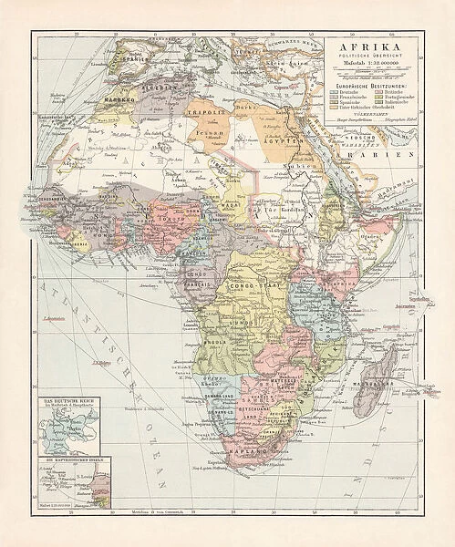
Political map of Africa, lithograph, published in 1899
![]()

Wall Art and Photo Gifts from Fine Art Storehouse
Political map of Africa, lithograph, published in 1899
Political map of Africa at the end of the 19th century. Lithograph, published in 1899
Unleash your creativity and transform your space into a visual masterpiece!
ZU_09
Media ID 20251037
FEATURES IN THESE COLLECTIONS
> Africa
> Related Images
> Fine Art Storehouse
> Map
> Historical Maps
> Maps and Charts
> Early Maps
EDITORS COMMENTS
This lithograph, titled "Political Map of Africa" takes us back to the end of the 19th century when the continent was undergoing significant changes. Created in 1899 by ZU_09, this print offers a glimpse into the political landscape that shaped Africa during that time. The map showcases various countries and territories as they existed at the turn of the century, providing valuable historical insight. Each border is meticulously drawn with intricate details, highlighting colonial boundaries and regional divisions that were prevalent during this era. As we examine this piece closely, it becomes evident how European powers had carved up Africa through colonization. The map reveals a complex web of imperial influence across vast stretches of land; from British-controlled regions in East and Southern Africa to French colonies in West and Central Africa. Beyond its historical significance, this lithograph also serves as a testament to human curiosity and exploration. It reminds us of an era when cartographers embarked on daring expeditions to chart uncharted territories, unraveling mysteries hidden within these vast landscapes. Preserved over time, this print captures not only geographical accuracy but also reflects artistic craftsmanship. Its elegant design and attention to detail make it an exquisite addition for any art enthusiast or history buff seeking to delve into Africa's past. Whether displayed in homes or educational institutions, "Political Map of Africa" invites viewers on a visual journey through time – offering both knowledge about our shared history and appreciation for fine artistry.
MADE IN AUSTRALIA
Safe Shipping with 30 Day Money Back Guarantee
FREE PERSONALISATION*
We are proud to offer a range of customisation features including Personalised Captions, Color Filters and Picture Zoom Tools
SECURE PAYMENTS
We happily accept a wide range of payment options so you can pay for the things you need in the way that is most convenient for you
* Options may vary by product and licensing agreement. Zoomed Pictures can be adjusted in the Cart.


