Home > Maps and Charts > World
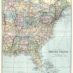
United States Eastern states map 1898

![]()
Wall Art and Photo Gifts from Fine Art Storehouse
United States Eastern states map 1898
Map from the Complete Handy Atlas of the World - 1898
Unleash your creativity and transform your space into a visual masterpiece!
THEPALMER
Media ID 20114751
© A 2014 Roberto Adrian Photography
FEATURES IN THESE COLLECTIONS
> Fine Art Storehouse
> Map
> Historical Maps
> Maps and Charts
> Early Maps
> Maps and Charts
> World
EDITORS COMMENTS
This print showcases a remarkable piece of history: the United States Eastern states map from 1898. A true treasure from the past, this map was originally featured in the Complete Handy Atlas of the World - an invaluable resource for explorers and geographers during that era. The intricate details and delicate craftsmanship captured in this print transport us back to a time when cartography was both an art form and a scientific endeavor. The map itself depicts the eastern region of the United States as it stood over a century ago, offering a glimpse into how these states were organized and interconnected at that time. From Maine's rugged coastline to Florida's sun-kissed shores, each state is meticulously outlined with precision and care. Rivers meander across the landscape like lifelines connecting communities, while mountain ranges rise majestically on paper. As we gaze upon this vintage masterpiece, we can't help but marvel at how much has changed since its creation. Urban sprawl has transformed quaint towns into bustling cities; transportation networks have expanded exponentially; borders have shifted due to political changes. Yet amidst all these transformations, one thing remains constant: our fascination with maps as windows into our world's rich history. "ThePALMER" has skillfully preserved this slice of American geography through their lens, allowing us to appreciate not only its historical significance but also its artistic allure. This print serves as a testament to human curiosity and exploration - reminding us that even in today's digital age, there is still something magical about holding tangible
MADE IN AUSTRALIA
Safe Shipping with 30 Day Money Back Guarantee
FREE PERSONALISATION*
We are proud to offer a range of customisation features including Personalised Captions, Color Filters and Picture Zoom Tools
SECURE PAYMENTS
We happily accept a wide range of payment options so you can pay for the things you need in the way that is most convenient for you
* Options may vary by product and licensing agreement. Zoomed Pictures can be adjusted in the Cart.