Home > Arts > Landscape paintings > Forest and woodland scenes > Forest artwork
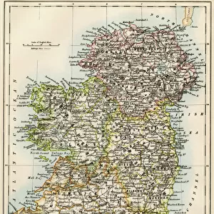
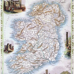
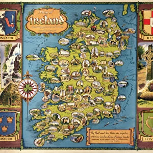
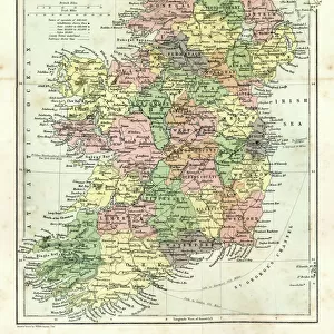
Antique Ireland Map

![]()
Wall Art and Photo Gifts from Fine Art Storehouse
Antique Ireland Map
Ireland Map, - Antique style. Includes mountains and water bodies. High detail - vector illustration
Unleash your creativity and transform your space into a visual masterpiece!
Media ID 13666567
Cartographer Computer Graphics Geographical Border Globe Intricacy Land National Northern Ireland Pencil Drawing Planet Space Republic Of Ireland Sketch Topography Vector World Map
FEATURES IN THESE COLLECTIONS
> Arts
> Landscape paintings
> Forest and woodland scenes
> Forest artwork
> Arts
> Realistic drawings
> Pencil drawings
> Black and white artwork
> Arts
> Realistic drawings
> Pencil drawings
> Fine art
> Arts
> Realistic drawings
> Pencil drawings
> Sketches
> Europe
> Republic of Ireland
> Lakes
> Related Images
> Europe
> Republic of Ireland
> Maps
> Europe
> Republic of Ireland
> Related Images
> Europe
> Republic of Ireland
> Rivers
> Europe
> United Kingdom
> Maps
> Europe
> United Kingdom
> Northern Ireland
> Lakes
> Fine Art Storehouse
> Map
> Historical Maps
EDITORS COMMENTS
This print takes us on a journey to the past, showcasing an antique map of Ireland in all its intricacy. The high detail and exquisite craftsmanship of this vector illustration transport us back in time, capturing the essence of a bygone era. The map features the stunning landscapes that define Ireland - from majestic mountains to meandering rivers and vast water bodies. Every contour is meticulously depicted, highlighting the country's topography with precision and artistry. As we gaze upon this computer-generated artwork, we can't help but appreciate the skill of the cartographer who painstakingly sketched every line and curve. The sea stretches out like an inked canvas while landmasses come alive with intricate details. This antique-style map not only showcases Ireland but also reminds us of our place within a larger world. It serves as a reminder that even though borders may change over time, geography remains constant. Whether you are an avid traveler or simply appreciate fine art, this print invites you to explore Ireland's rich history and natural beauty. Its vintage charm adds character to any space it graces, making it perfect for those seeking both aesthetic appeal and historical significance. With its timeless design and impeccable execution, this antique Ireland map offers a glimpse into the past while celebrating the enduring allure of cartography as an art form.
MADE IN AUSTRALIA
Safe Shipping with 30 Day Money Back Guarantee
FREE PERSONALISATION*
We are proud to offer a range of customisation features including Personalised Captions, Color Filters and Picture Zoom Tools
SECURE PAYMENTS
We happily accept a wide range of payment options so you can pay for the things you need in the way that is most convenient for you
* Options may vary by product and licensing agreement. Zoomed Pictures can be adjusted in the Cart.