Home > Europe > United Kingdom > Wales > Maps
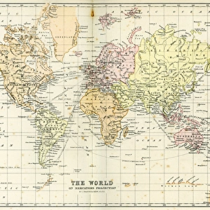
Antique Map of England and Wales 1880s

![]()
Wall Art and Photo Gifts from Fine Art Storehouse
Antique Map of England and Wales 1880s
Vintage 19th Century map of England and Wales
Unleash your creativity and transform your space into a visual masterpiece!
duncan1890
Media ID 13666703
© duncan1890
1880 1889 66697 78279 Equipment Ilustration Image Created 1880 1889 Memories Navigational Equipment Northeastern England Northern Europe Northwest England Nostalgia Retro Revival Road Map Southeast England Southwest England Styles Wales Drawing Art Product Eastern England Image Created 19th Century Retro Styled Victorian Style
FEATURES IN THESE COLLECTIONS
> Europe
> United Kingdom
> England
> Maps
> Europe
> United Kingdom
> Maps
> Europe
> United Kingdom
> Wales
> Maps
> Fine Art Storehouse
> Map
> Historical Maps
> Maps and Charts
> Early Maps
> Maps and Charts
> Wales
EDITORS COMMENTS
This print takes us back to the enchanting era of the 19th century with its Antique Map of England and Wales. The intricate details and craftsmanship showcased in this vintage cartography piece evoke a sense of nostalgia, transporting us to a time when maps were meticulously engraved images created through woodcut illustrations. The map, dating from the 1880s, captures the essence of Victorian style with its ornate design and historical significance. It provides a glimpse into the past, allowing us to explore the roadways and regions of northeastern England, northwest England, eastern England, southwest England, and southeast England as they were over a century ago. As we gaze upon this print, we are reminded of how navigational equipment has evolved throughout history. This drawing art product serves as both an educational tool and a work of art that beautifully encapsulates memories from bygone times. With its retro-styled charm and attention to detail, this Antique Map offers more than just geographical information; it invites us on a journey through time. Whether you have an affinity for history or simply appreciate the beauty found in old-world aesthetics, this print is sure to captivate your imagination. Let yourself be transported back to 19th-century Europe as you admire this remarkable piece by duncan1890 from Fine Art Storehouse.
MADE IN AUSTRALIA
Safe Shipping with 30 Day Money Back Guarantee
FREE PERSONALISATION*
We are proud to offer a range of customisation features including Personalised Captions, Color Filters and Picture Zoom Tools
SECURE PAYMENTS
We happily accept a wide range of payment options so you can pay for the things you need in the way that is most convenient for you
* Options may vary by product and licensing agreement. Zoomed Pictures can be adjusted in the Cart.