Home > Animals > Insects > Hemiptera > Black Scale
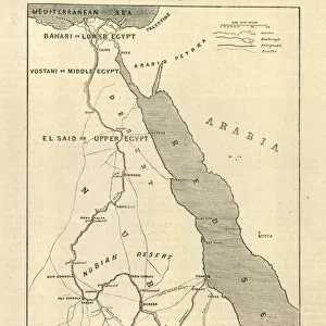
Antique map of Turkey in Asia, Egypt, Arabia, and Persia

![]()
Wall Art and Photo Gifts from Fine Art Storehouse
Antique map of Turkey in Asia, Egypt, Arabia, and Persia
Unleash your creativity and transform your space into a visual masterpiece!
Hemera Technologies
Media ID 13667353
© Getty Images
Arabian Peninsula Black Color Border Direction Document Egypt Geography Indian Ocean Iran Latitude Legend Location Longitude Mediterranean Mediterranean Culture Middle East Nubia Persia Persian Gulf Place Positioning Red Sea Saudi Arabia Scale Sinai Egypt Sinai Peninsula Suez Turkey Turkey Middle East Caspian Turkish Empire
FEATURES IN THESE COLLECTIONS
> Animals
> Insects
> Hemiptera
> Black Scale
> Asia
> Saudi Arabia
> Maps
> Asia
> Turkey
> Related Images
> Europe
> Related Images
> Fine Art Storehouse
> Map
> Historical Maps
> Maps and Charts
> Early Maps
EDITORS COMMENTS
This antique map, titled "Antique Map of Turkey in Asia, Egypt, Arabia, and Persia" takes us on a journey through the rich history and diverse landscapes of the Middle East. Created by Hemera Technologies, this print showcases intricate cartography skills that were employed to depict an extensive region spanning from Turkey to Egypt and from Arabia to Persia. The black border surrounding the map adds a touch of elegance while emphasizing its archival value. The detailed engravings highlight key geographical features such as the Caspian Sea, Indian Ocean, Red Sea, Persian Gulf, and Mediterranean Sea. It also includes significant landmarks like the Sinai Peninsula and Suez Canal. With its precise latitude and longitude lines accompanied by a legend indicating scale measurements, this vintage piece serves not only as an artistic representation but also as a valuable historical document. Its monochromatic color scheme exudes an air of sophistication while capturing the essence of ancient times. As we gaze upon this remarkable artwork outdoors or within our own homes or offices, it transports us back in time to explore the cultural heritage embedded within these lands. From Nubia's ancient civilization to Saudi Arabia's majestic landscapes; from Iran's vibrant culture to Turkey's historical significance – every inch of this map invites us on an adventure through centuries past. Let this exquisite print ignite your curiosity about these enchanting regions where civilizations have flourished for millennia. Immerse yourself in their physical geography and positioning with this meticulously crafted masterpiece that celebrates both artistry and history
MADE IN AUSTRALIA
Safe Shipping with 30 Day Money Back Guarantee
FREE PERSONALISATION*
We are proud to offer a range of customisation features including Personalised Captions, Color Filters and Picture Zoom Tools
SECURE PAYMENTS
We happily accept a wide range of payment options so you can pay for the things you need in the way that is most convenient for you
* Options may vary by product and licensing agreement. Zoomed Pictures can be adjusted in the Cart.