Home > Maps and Charts > Early Maps
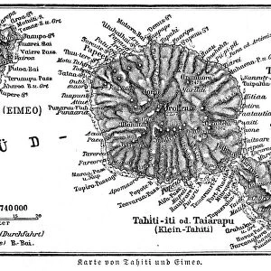
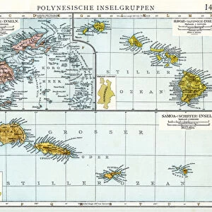
Antique maps of Tahiti and other South Pacific islands

![]()
Wall Art and Photo Gifts from Fine Art Storehouse
Antique maps of Tahiti and other South Pacific islands
Unleash your creativity and transform your space into a visual masterpiece!
Hemera Technologies
Media ID 13609521
© Getty Images
18th Century 18th Century Style Archipelago Border Chart Cook Cookery Direction Document Four French Overseas Territory Geographical Locations Geography Island Islands Legend Locations Maps Navigation Places Scale Scene South Pacific South Pacific Ocean Charts Hogg Tahiti
FEATURES IN THESE COLLECTIONS
> Fine Art Storehouse
> Map
> Historical Maps
> Maps and Charts
> Early Maps
EDITORS COMMENTS
This print by Hemera Technologies showcases a collection of antique maps depicting the enchanting islands of Tahiti and other South Pacific gems. Dating back to the 18th century, these archival treasures offer a glimpse into the rich history and exploration of this idyllic archipelago. The intricate engravings beautifully capture the geography and cartography of each island, providing valuable navigation charts for seafarers during that era. The borders are adorned with delicate details, while legends and keys guide viewers through the various locations depicted on these vintage maps. As we delve into this visual journey, we are transported to a time when Captain Cook's voyages brought these remote paradises to light. Each map tells its own story, revealing not only physical features but also historical significance associated with Tahiti and its neighboring islands. With no people in sight, our focus is solely on these remarkable artifacts which have stood the test of time. The horizontal composition allows us to appreciate every inch of detail as we explore this sea of knowledge. Whether you are an avid collector or simply intrigued by history and geography, this print invites you to immerse yourself in the beauty and allure of Tahiti's past. Let it serve as a reminder that even centuries later, these South Pacific wonders continue to captivate hearts worldwide.
MADE IN AUSTRALIA
Safe Shipping with 30 Day Money Back Guarantee
FREE PERSONALISATION*
We are proud to offer a range of customisation features including Personalised Captions, Color Filters and Picture Zoom Tools
SECURE PAYMENTS
We happily accept a wide range of payment options so you can pay for the things you need in the way that is most convenient for you
* Options may vary by product and licensing agreement. Zoomed Pictures can be adjusted in the Cart.