Home > Arts > Realistic drawings > Pencil drawings > Black and white artwork
Antique North Carolina

![]()
Wall Art and Photo Gifts from Fine Art Storehouse
Antique North Carolina
Unleash your creativity and transform your space into a visual masterpiece!
Media ID 13666547
Cartographer Computer Graphic Computer Graphics East Geographical Border Global Globe Navigational Equipment Intricacy Land National North North Carolina Us State Pencil Drawing Planet Space Sketch State Topography Vector Drawing Art Product White Color
FEATURES IN THESE COLLECTIONS
> Arts
> Landscape paintings
> Forest and woodland scenes
> Forest artwork
> Arts
> Realistic drawings
> Pencil drawings
> Black and white artwork
> Arts
> Realistic drawings
> Pencil drawings
> Fine art
> Arts
> Realistic drawings
> Pencil drawings
> Sketches
> Fine Art Storehouse
> Map
> Historical Maps
> Fine Art Storehouse
> Map
> USA Maps
> Maps and Charts
> Early Maps
> Maps and Charts
> Related Images
> North America
> United States of America
> Lakes
> Related Images
> North America
> United States of America
> Maps
> North America
> United States of America
> North Carolina
> Related Images
EDITORS COMMENTS
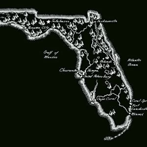
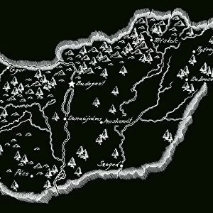
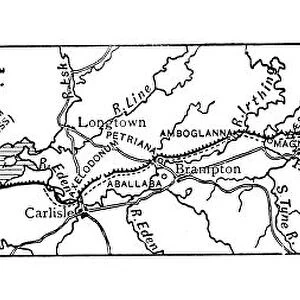
This print takes us on a journey through the rich history of Antique North Carolina. The intricate details, meticulously crafted by a skilled cartographer, showcase the beauty and complexity of this eastern state in the USA. The artist's use of computer graphics gives a modern twist to this antique map, blending the past with contemporary artistry. The engraving depicts a stunning topography that includes mountains, forests, rivers, and lakes. Each element is carefully etched into the illustration using ink and pencil drawing techniques. The geographical borders are clearly defined, highlighting North Carolina's place within the nation. As we explore this ancient map, our eyes are drawn to the sea surrounding its shores—a reminder of North Carolina's coastal charm and maritime heritage. This engraved image transports us back in time when navigational equipment relied upon globes to guide sailors across vast oceans. With its blend of historical accuracy and artistic flair, this print serves as both an educational tool and a beautiful piece of decor for any space. Whether you're fascinated by cartography or simply appreciate fine art craftsmanship, this Antique North Carolina print will surely captivate your imagination with its timeless allure.
MADE IN AUSTRALIA
Safe Shipping with 30 Day Money Back Guarantee
FREE PERSONALISATION*
We are proud to offer a range of customisation features including Personalised Captions, Color Filters and Picture Zoom Tools
SECURE PAYMENTS
We happily accept a wide range of payment options so you can pay for the things you need in the way that is most convenient for you
* Options may vary by product and licensing agreement. Zoomed Pictures can be adjusted in the Cart.