Home > Arts > Landscape paintings > Waterfall and river artworks > River artworks
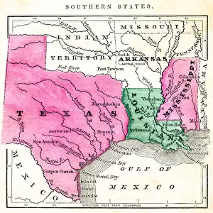
Antquie Map of the United States

![]()
Wall Art and Photo Gifts from Fine Art Storehouse
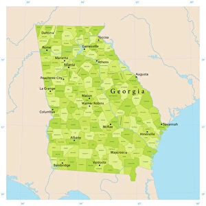
Antquie Map of the United States
Vintage map of the United States of America from 1837
Unleash your creativity and transform your space into a visual masterpiece!
duncan1890
Media ID 13666633
© duncan1890
Alabama American Culture Arkansas Canada Chart Eastern Usa Florida Florida Us State Geographical Locations Georgia Georgia Us State Great Lakes Gulf Coast States Illinois Indiana Kentucky Lake Erie Lake Michigan Lake Superior Louisiana Maine Michigan Mid Atlantic Usa Midwest Usa Mississippi Mississippi River Missouri Navigational Equipment New England New England Usa New York City New York State North America North Carolina North Carolina Us State Ohio Past Pennsylvania South Carolina Southern Usa Styles Tennessee The Americas Virginia Virginia Us State Image Created 19th Century Lake Huron Lake Ontario Obsolete
FEATURES IN THESE COLLECTIONS
> Arts
> Landscape paintings
> Waterfall and river artworks
> River artworks
> Europe
> France
> Canton
> Maine
> Europe
> United Kingdom
> England
> Lakes
> Europe
> United Kingdom
> England
> Maps
> Europe
> United Kingdom
> England
> Rivers
> Europe
> United Kingdom
> England
> York
> Fine Art Storehouse
> Map
> Historical Maps
> Fine Art Storehouse
> Map
> USA Maps
> USA Southern States Historical Maps
> Fine Art Storehouse
> Map
> USA Maps
> Maps and Charts
> Early Maps
EDITORS COMMENTS
This print takes us back in time to the year 1837, showcasing an exquisite vintage map of the United States of America. With its intricate details and 19th-century style, this antique piece offers a glimpse into the rich history and cultural heritage of American society. The image, created through engraved techniques commonly used during that era, beautifully captures the eastern region of the USA, including Lake Huron, Lake Erie, Lake Ontario, and Lake Superior. As we explore this map further, we are reminded of how cartography played a crucial role in navigation during those times. This particular chart highlights various geographical locations such as Florida, Illinois, Ohio, Indiana, Michigan Missouri - representing the Midwest USA - Maine and New England states like New York City and Virginia. It also encompasses parts of Pennsylvania in the Mid-Atlantic USA as well as Southern states like South Carolina Louisiana Tennessee Mississippi Kentucky Georgia Arkansas Alabama. The Great Lakes stand out prominently on this map; their importance for trade and transportation cannot be overstated. Furthermore, the presence of Canada reminds us that North America is not limited to just one country but rather a continent with diverse nations. Duncan1890's photograph expertly captures this historical artifact with horizontal precision while emphasizing its age through faded tones reminiscent of early photography techniques from the 19th century. As we gaze upon it today in awe-struck wonderment at our past's intricacies unfold before our eyes once more – reminding us how far we have come since then.
MADE IN AUSTRALIA
Safe Shipping with 30 Day Money Back Guarantee
FREE PERSONALISATION*
We are proud to offer a range of customisation features including Personalised Captions, Color Filters and Picture Zoom Tools
SECURE PAYMENTS
We happily accept a wide range of payment options so you can pay for the things you need in the way that is most convenient for you
* Options may vary by product and licensing agreement. Zoomed Pictures can be adjusted in the Cart.