Home > North America > Canada > Maps
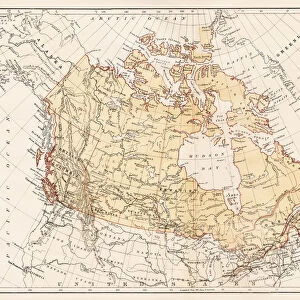
Canada map 1898

![]()
Wall Art and Photo Gifts from Fine Art Storehouse
Canada map 1898
Unleash your creativity and transform your space into a visual masterpiece!
THEPALMER
Media ID 14756952
© This content is subject to copyright
FEATURES IN THESE COLLECTIONS
> Fine Art Storehouse
> Map
> Historical Maps
> Maps and Charts
> Early Maps
> North America
> Canada
> Maps
EDITORS COMMENTS
This print titled "Canada map 1898" takes us on a journey back in time, offering a glimpse into the rich history and vast landscapes of Canada at the turn of the 20th century. The intricate details and meticulous craftsmanship showcased in this piece make it truly remarkable. The map, created by THEPALMER, captures the essence of Canada's diverse provinces and territories as they were in 1898. From the rugged mountains of British Columbia to the expansive prairies of Alberta and Saskatchewan, every region is beautifully depicted with precision and accuracy. Rivers meander gracefully across the canvas, while lakes shimmer like jewels amidst lush forests. As we explore this vintage treasure, our eyes are drawn to important cities such as Toronto, Montreal, Vancouver, and Ottawa - each marked with delicate dots that indicate their significance within Canadian history. This snapshot from over a century ago allows us to reflect upon how much has changed since then while appreciating the enduring beauty that still defines these places today. Whether you're an avid historian or simply fascinated by cartography, this stunning print will undoubtedly spark conversations about Canada's past. It serves as a reminder of our nation's vastness and diversity – both geographically and culturally – inviting us to appreciate its natural wonders and embrace its multicultural heritage. Displaying "Canada map 1898" in your home or office not only adds an air of sophistication but also pays homage to our country's roots. Let it transport you back in time while celebrating all that makes
MADE IN AUSTRALIA
Safe Shipping with 30 Day Money Back Guarantee
FREE PERSONALISATION*
We are proud to offer a range of customisation features including Personalised Captions, Color Filters and Picture Zoom Tools
SECURE PAYMENTS
We happily accept a wide range of payment options so you can pay for the things you need in the way that is most convenient for you
* Options may vary by product and licensing agreement. Zoomed Pictures can be adjusted in the Cart.