Home > Oceania > Australia > Maps
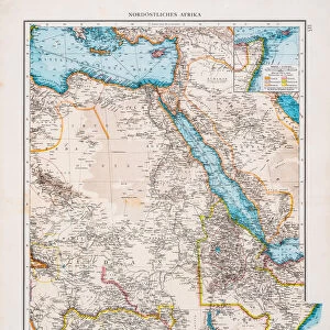
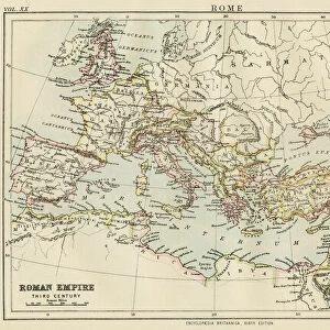
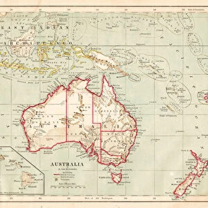
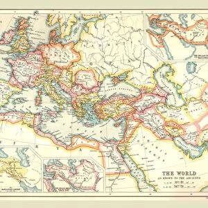
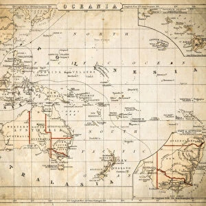
Easter hemisphere map 1867

![]()
Wall Art and Photo Gifts from Fine Art Storehouse
Easter hemisphere map 1867
Mitchellas Modern Atlas - Published by E.H. Butler and Co - Philadelphia 1867
Unleash your creativity and transform your space into a visual masterpiece!
THEPALMER
Media ID 13609189
© This content is subject to copyright
Australia Eastern Hemisphere Hemisphere North America South America Hemispheres
FEATURES IN THESE COLLECTIONS
> Africa
> Related Images
> Asia
> Related Images
> Europe
> Related Images
> Fine Art Storehouse
> Map
> Historical Maps
> Fine Art Storehouse
> Map
> USA Maps
> Maps and Charts
> Early Maps
> North America
> United States of America
> Maps
EDITORS COMMENTS
This print showcases an exquisite piece of cartographic history, the "Easter Hemisphere Map 1867". Published by E. H. Butler and Co in Philadelphia during the same year, this remarkable artifact takes us back to a time when exploration and discovery were at their peak. The map encompasses continents like Africa, Asia, Australia, Europe, South America, and North America with meticulous detail. Crafted through engraving and etching techniques on lithograph paper, this antique map exudes a sense of elegance that transports us to a bygone era. Its horizontal orientation allows for easy examination of physical geography across different regions. The artist behind this masterpiece is THEPALMER from Fine Art Storehouse who has flawlessly captured every intricate detail of the original illustration. As we gaze upon this historical gem hanging on our walls or displayed in our study rooms, it serves as a reminder of how far our understanding of the world has come. Whether you are an avid collector or simply appreciate art's ability to connect us with the past, this Easter Hemisphere Map 1867 print will undoubtedly be a cherished addition to your collection. Let its timeless beauty transport you back in time as you marvel at the vastness and diversity of our planet's landscapes depicted within its borders.
MADE IN AUSTRALIA
Safe Shipping with 30 Day Money Back Guarantee
FREE PERSONALISATION*
We are proud to offer a range of customisation features including Personalised Captions, Color Filters and Picture Zoom Tools
SECURE PAYMENTS
We happily accept a wide range of payment options so you can pay for the things you need in the way that is most convenient for you
* Options may vary by product and licensing agreement. Zoomed Pictures can be adjusted in the Cart.