Home > Africa > Sudan > Maps
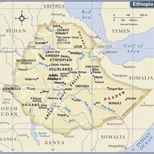
Egypt Darfur Abyssinian map 1895

![]()
Wall Art and Photo Gifts from Fine Art Storehouse
Egypt Darfur Abyssinian map 1895
Meyers Konversations-Lexikon. Ein Nachschlagewerk des allgemeinen Wissens, 5th edition 17 volumes Bibliographisches Institut - Leipzig 1895-1897
Unleash your creativity and transform your space into a visual masterpiece!
THEPALMER
Media ID 13609375
© This content is subject to copyright
Atlas Mythological Figure Egypt Ethiopia Horn Of Africa Middle East Nubia Paper Red Sea Sudan World Map Darfur
FEATURES IN THESE COLLECTIONS
> Africa
> Ethiopia (Abyssinia)
> Related Images
> Africa
> Ethiopia
> Related Images
> Fine Art Storehouse
> Map
> Historical Maps
> Maps and Charts
> Early Maps
> Maps and Charts
> World
> North America
> United States of America
> Maps
EDITORS COMMENTS
This print takes us back to the year 1895, where we find ourselves immersed in a world of ancient cartography. The image showcases an intricate map titled "Egypt Darfur Abyssinian map" sourced from the renowned Meyers Konversations-Lexikon. This fifth edition, spanning across 17 volumes, was a comprehensive compendium of general knowledge published by Bibliographisches Institut in Leipzig between 1895 and 1897. The map itself is a true testament to the artistry and craftsmanship of its time. With its vertical orientation, it elegantly displays the Middle East region with great detail and precision. From Egypt to Ethiopia, Sudan to Nubia, every corner is meticulously illustrated on this antique piece of paper. As our eyes wander across this historic artifact, we are transported through time and space. We can almost feel the weight of history as we trace our fingers along the contours of each engraved line that depicts physical geography - mountains, rivers, deserts - all contributing to shaping these lands. The inclusion of mythological figures such as Atlas adds an air of mystique to this already enchanting composition. It serves as a reminder that maps not only guide us physically but also ignite our imagination. With its faded hues and delicate texture reminiscent of old-world charm, this print invites us to appreciate both the beauty and significance held within vintage cartography. As we gaze upon it today in awe-inspired wonderment from Fine Art Storehouse's collection curated by THEPALMER
MADE IN AUSTRALIA
Safe Shipping with 30 Day Money Back Guarantee
FREE PERSONALISATION*
We are proud to offer a range of customisation features including Personalised Captions, Color Filters and Picture Zoom Tools
SECURE PAYMENTS
We happily accept a wide range of payment options so you can pay for the things you need in the way that is most convenient for you
* Options may vary by product and licensing agreement. Zoomed Pictures can be adjusted in the Cart.