Home > Asia > Iran > Maps
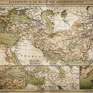
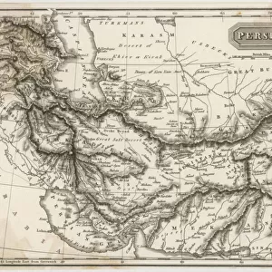
Empire of Alexander the Great, hand-coloured steel engraving, published 1861

![]()
Wall Art and Photo Gifts from Fine Art Storehouse
Empire of Alexander the Great, hand-coloured steel engraving, published 1861
Antique map from Empire of Alexander the Great 356 - 326 BC) after the battle of Ipsos (301 BC). Legend in Latin language. Steel engraving with hand colored borderlines, published in 1861
Unleash your creativity and transform your space into a visual masterpiece!
Media ID 13666865
© ZU_09
Afrika Afrika Alexander The Great Arabia Asian And Indian Ethnicities Classical Greek East Asian Culture Empire European Culture Greece Greek Culture India Iran Mediterranean Countries Mediterranean Culture Mediterranean Sea Middle East Persian Culture Steel Engraving Topography
FEATURES IN THESE COLLECTIONS
> Africa
> Related Images
> Fine Art Storehouse
> History
> Battles & Wars
> Historcal Battle Maps and Plans
> Fine Art Storehouse
> Legends and Icons
> Famous Military Leaders
> Alexander the Great (356 bc-323 bc)
> Fine Art Storehouse
> Map
> Historical Maps
> Maps and Charts
> Early Maps
> Maps and Charts
> India
EDITORS COMMENTS
This print showcases an exquisite hand-coloured steel engraving of the Empire of Alexander the Great, dating back to 1861. The antique map depicts the vast territories conquered by this legendary ruler between 356 and 326 BC, following his triumphant victory at the battle of Ipsos in 301 BC. With a Latin legend accompanying it, this piece represents a fusion of European culture and ancient civilizations from across the Mediterranean region. The intricate details captured in this engraved image offer a glimpse into the topography and boundaries that shaped Alexander's empire. From Greece to Asia, Persia to India, Arabia to Africa, this map portrays an expansive domain that spanned continents and encompassed diverse cultures. The hand-coloured borderlines add depth and vibrancy to this historical artwork while highlighting different regions within the empire. It is fascinating how Greek currency influenced trade routes throughout these lands, connecting Asian and Indian ethnicities with classical Greek culture. As we delve into history through Peter Alexander's remarkable steel engraving, we are reminded of our rich past and how ancient civilizations have shaped our present world. This horizontal composition invites us on a visual journey through time as we explore Mediterranean culture intertwined with East Asian influences. Whether you appreciate cartography or simply admire art that tells stories from centuries ago, this enchanting print offers both aesthetic pleasure and intellectual curiosity for those fascinated by history's grand tapestry.
MADE IN AUSTRALIA
Safe Shipping with 30 Day Money Back Guarantee
FREE PERSONALISATION*
We are proud to offer a range of customisation features including Personalised Captions, Color Filters and Picture Zoom Tools
SECURE PAYMENTS
We happily accept a wide range of payment options so you can pay for the things you need in the way that is most convenient for you
* Options may vary by product and licensing agreement. Zoomed Pictures can be adjusted in the Cart.