Home > Europe > Germany > Maps
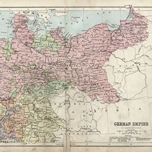
German federal state of Bavaria, lithograph, published in 1874

![]()
Wall Art and Photo Gifts from Fine Art Storehouse
German federal state of Bavaria, lithograph, published in 1874
Map of German federal state of Bavaria. Lithograph, published in 1874
Unleash your creativity and transform your space into a visual masterpiece!
Media ID 13666709
© ZU_09
Bavaria Contour Drawing Country Geographic Area Donny Deutsch Fax Machine Federal State German Culture Land Topographic Map Topography
FEATURES IN THESE COLLECTIONS
> Fine Art Storehouse
> Map
> Historical Maps
> Maps and Charts
> Early Maps
EDITORS COMMENTS
This lithograph, published in 1874, showcases the German federal state of Bavaria in all its glory. The intricate engraving and topographic details bring this historical map to life, offering a glimpse into the rich culture and landscape of Bavaria. From the majestic peaks of the Alps to the rolling hills and picturesque valleys, every contour is meticulously drawn with precision. Bavaria's distinct vertical shape dominates the composition, reminding us of its significance as one of Germany's largest states. This artwork serves as a testament to both cartography and photography techniques prevalent during that era. The absence of people allows us to focus solely on the land itself, emphasizing its natural beauty without any distractions. As we explore this remarkable piece further, it becomes evident that it was created with great care and attention to detail. While gazing at this lithograph today in 2021, we can't help but appreciate how it has stood the test of time. It serves as a reminder not only of Bavaria's geographical features but also its cultural heritage that has endured for centuries. Whether you are an art enthusiast or simply intrigued by history and geography, this print offers a fascinating glimpse into Bavaria's past – a true gem from Fine Art Storehouse collection.
MADE IN AUSTRALIA
Safe Shipping with 30 Day Money Back Guarantee
FREE PERSONALISATION*
We are proud to offer a range of customisation features including Personalised Captions, Color Filters and Picture Zoom Tools
SECURE PAYMENTS
We happily accept a wide range of payment options so you can pay for the things you need in the way that is most convenient for you
* Options may vary by product and licensing agreement. Zoomed Pictures can be adjusted in the Cart.