Home > Europe > United Kingdom > England > London > Art > Paintings
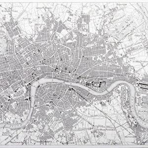
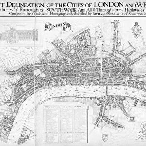
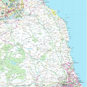
London, England Circa 1850 Engraving

![]()
Wall Art and Photo Gifts from Fine Art Storehouse
London, England Circa 1850 Engraving
Engraved illustrations of the city of London, England from Iconographic Encyclopedia of Science, Literature and Art, Published in 1851. Copyright has expired on this artwork. Digitally restored
Unleash your creativity and transform your space into a visual masterpiece!
bauhaus1000
Media ID 13666955
© Craig McCausland
1850 1859 British Culture Chart City Map Diagram Drypoint English Culture Image Created 1850 1859 London England Plan Thames River Urban Scene World Map Drawing Art Product Image Created 19th Century
FEATURES IN THESE COLLECTIONS
> Arts
> Landscape paintings
> Waterfall and river artworks
> River artworks
> Arts
> Literature
> Illustration
> Arts
> Literature
> Arts
> Portraits
> Pop art gallery
> Street art portraits
> Europe
> United Kingdom
> England
> London
> Art
> Paintings
> Europe
> United Kingdom
> England
> London
> Boroughs
> City of London
> Europe
> United Kingdom
> England
> London
> River Thames
> Europe
> United Kingdom
> England
> Maps
> Europe
> United Kingdom
> England
> Paintings
> Europe
> United Kingdom
> England
> Rivers
> Fine Art Storehouse
> Map
> Historical Maps
EDITORS COMMENTS
This print takes us back in time to the bustling streets of London, England circa 1850. The engraving, sourced from the Iconographic Encyclopedia of Science, Literature and Art published in 1851, showcases a remarkable piece of history that has now entered the public domain. Painstakingly digitally restored, this image allows us to appreciate the intricate details and artistry of 19th-century style cartography. As we gaze upon this enchanting illustration and painting, we are transported to an era when travel and tourism were beginning to flourish. The city map depicted here offers a glimpse into London's physical geography during that period - its winding streets intertwining with the majestic Thames River. The absence of people in this horizontal composition adds an air of tranquility while highlighting the architectural marvels that define English culture. This meticulously crafted engraving captures not only a moment frozen in time but also serves as a testament to British urban scene at its prime. Whether you are an avid history enthusiast or simply captivated by art and craft, this exquisite print is sure to ignite your imagination. Let it transport you back through centuries as you explore every minute detail etched onto paper over one hundred fifty years ago.
MADE IN AUSTRALIA
Safe Shipping with 30 Day Money Back Guarantee
FREE PERSONALISATION*
We are proud to offer a range of customisation features including Personalised Captions, Color Filters and Picture Zoom Tools
SECURE PAYMENTS
We happily accept a wide range of payment options so you can pay for the things you need in the way that is most convenient for you
* Options may vary by product and licensing agreement. Zoomed Pictures can be adjusted in the Cart.