Home > North America > United States of America > New York > New York > Maps
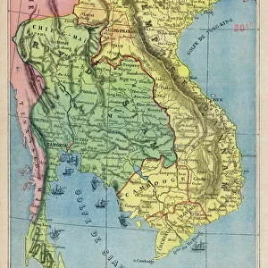
Malay peninsula map 1883

![]()
Wall Art and Photo Gifts from Fine Art Storehouse
Malay peninsula map 1883
Encyclopedia Britannica 9th Edition New York Samuel L. Hall 1883 Vol XV
Unleash your creativity and transform your space into a visual masterpiece!
THEPALMER
Media ID 14756784
© This content is subject to copyright
FEATURES IN THESE COLLECTIONS
> Asia
> Turkmenistan
> Maps
> Fine Art Storehouse
> Map
> Historical Maps
> Maps and Charts
> Early Maps
> North America
> United States of America
> New York
> New York
> Maps
EDITORS COMMENTS
In this print titled "Malay Peninsula Map 1883" we are transported back in time to the late 19th century. The map, sourced from the Encyclopedia Britannica's 9th Edition, New York, and curated by Samuel L. Hall in 1883, offers a fascinating glimpse into the geographical landscape of Southeast Asia during that era. The intricate details and delicate craftsmanship of this vintage map immediately catch our attention. It showcases the Malay Peninsula with remarkable precision, highlighting significant regions such as Malaisa (now Malaysia), Siam (present-day Thailand), Sumatra, and more. Each contour and coastline is meticulously drawn, revealing an artist's dedication to accuracy. As we explore this historical artifact further, it becomes evident that its purpose extends beyond mere cartography. It serves as a window into a bygone era when colonial powers were expanding their influence across distant lands. The names of various territories evoke a sense of nostalgia for an age marked by exploration and discovery. "The Malay Peninsula Map 1883" transports us to a time when borders were fluid and cultures intertwined along trade routes connecting East and West. Its presence on display at Fine Art Storehouse allows us to appreciate both its aesthetic beauty as well as its historical significance. Through THEPALMER's lens capturing every intricate detail of this extraordinary piece, viewers can now own a tangible connection to history—a visual reminder of how maps have shaped our understanding of the world throughout centuries past.
MADE IN AUSTRALIA
Safe Shipping with 30 Day Money Back Guarantee
FREE PERSONALISATION*
We are proud to offer a range of customisation features including Personalised Captions, Color Filters and Picture Zoom Tools
SECURE PAYMENTS
We happily accept a wide range of payment options so you can pay for the things you need in the way that is most convenient for you
* Options may vary by product and licensing agreement. Zoomed Pictures can be adjusted in the Cart.