Home > Europe > United Kingdom > England > Lincolnshire > Stamford
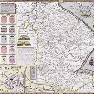
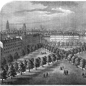
Map of Burghley and Neighborhoods, England Victorian Engraving, 1840

![]()
Wall Art and Photo Gifts from Fine Art Storehouse
Map of Burghley and Neighborhoods, England Victorian Engraving, 1840
Very Rare, Beautifully Illustrated Antique Engraving of Map of Burghley and Neighborhoods, England Victorian Engraving, 1840 from Our Own Country, Great Britain, Descriptive, Historical, Pictorial. Published in 1880. Copyright has expired on this artwork. Digitally restored
Unleash your creativity and transform your space into a visual masterpiece!
bauhaus1000
Media ID 13667205
© bauhaus1000
1840 1849 78279 89182 Art Product British Culture Chart Diagram Direction English Culture Graph Image Created 1840 1849 Lincolnshire Northamptonshire Plan Residential District Thoroughfare Village Burghley Image Created 19th Century Victorian Style
FEATURES IN THESE COLLECTIONS
> Arts
> Portraits
> Pop art gallery
> Street art portraits
> Europe
> United Kingdom
> England
> Cambridgeshire
> Peterborough
> Europe
> United Kingdom
> England
> Lincolnshire
> Stamford
> Europe
> United Kingdom
> England
> Maps
> Europe
> United Kingdom
> England
> Northamptonshire
> Old
> Europe
> United Kingdom
> England
> Peterborough
> Europe
> United Kingdom
> Maps
> Fine Art Storehouse
> Map
> Historical Maps
> Maps and Charts
> Early Maps
EDITORS COMMENTS
This beautifully illustrated antique engraving captures the essence of Burghley and its surrounding neighborhoods in England during the Victorian era. Created in 1840, this rare map showcases the intricate details of the area, providing a descriptive and historical glimpse into Great Britain's past. Published in 1880, this print has been digitally restored to revive its original charm. The enchanting image takes us back to a time when cartography was an art form, with meticulously etched lines and delicate illustrations that bring life to every corner of Burghley. From Peterborough Cambridgeshire to Stamford England, from Northamptonshire to Lincolnshire, this map guides us through streets, roads, and thoroughfares that once shaped these residential districts. As we explore this Victorian-style masterpiece, we are transported into English culture and British history. The famous landmarks of Burghley come alive on paper – their grandeur captured for eternity. This print serves as both a piece of art and a valuable historical artifact. Whether you're an avid traveler or simply appreciate the beauty of vintage maps, this engraving is sure to captivate your imagination. Its timeless design transcends centuries while preserving the spirit of 19th-century craftsmanship. Step into the past with this remarkable piece that celebrates not only Burghley but also the rich heritage embedded within its streets and alleys.
MADE IN AUSTRALIA
Safe Shipping with 30 Day Money Back Guarantee
FREE PERSONALISATION*
We are proud to offer a range of customisation features including Personalised Captions, Color Filters and Picture Zoom Tools
SECURE PAYMENTS
We happily accept a wide range of payment options so you can pay for the things you need in the way that is most convenient for you
* Options may vary by product and licensing agreement. Zoomed Pictures can be adjusted in the Cart.