Home > Arts > Minimalist artwork > Monochrome artwork > Black and white artwork
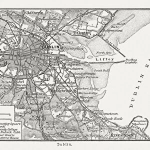
Map of Dublin in 1610 (Victorian engraving

![]()
Wall Art and Photo Gifts from Fine Art Storehouse
Map of Dublin in 1610 (Victorian engraving
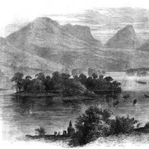
A map of Dublin, Ireland, as it was in 1610 AD. Dublin is the capital of the Republic of Ireland, which, at the time the engraving was made, was part of Great Britain. From Our Own Country: Descriptive, Historical, Pictoriala published by Cassell & Co Ltd, 1885
Unleash your creativity and transform your space into a visual masterpiece!
whitemay
Media ID 13667311
© This content is subject to copyright
17th Century 17th Century Style British Culture Dublin Republic Of Ireland Ireland Irish Culture Line Art Monochrome Nostalgia Sailing Ship Social History
FEATURES IN THESE COLLECTIONS
> Arts
> Landscape paintings
> Waterfall and river artworks
> River artworks
> Arts
> Minimalist artwork
> Monochrome artwork
> Black and white artwork
> Arts
> Minimalist artwork
> Monochrome artwork
> Fine art
> Arts
> Minimalist artwork
> Monochrome artwork
> Monochrome paintings
> Arts
> Portraits
> Pop art gallery
> Street art portraits
> Europe
> Republic of Ireland
> Dublin
> Europe
> Republic of Ireland
> Maps
> Europe
> United Kingdom
> Maps
> Fine Art Storehouse
> Map
> Historical Maps
> Fine Art Storehouse
> Travel Imagery
> Travel Destinations
> Ireland
> Dublin, Ireland
> Maps and Charts
> Early Maps
EDITORS COMMENTS
This print takes us back in time to the vibrant city of Dublin as it stood in 1610. The Victorian engraving, sourced from an esteemed publication titled "Our Own Country: Descriptive, Historical, Pictorial" offers a glimpse into the rich history and tradition of Ireland's capital during its affiliation with Great Britain. The intricate details showcased in this monochrome image transport us to a bygone era. We can trace the winding streets and alleyways that once bustled with activity, leading our imagination through the heart of this historic town. The Liffey River gracefully cuts through Dublin, serving as both a lifeline for trade and a picturesque backdrop for daily life. As we explore further, our eyes are drawn to an array of nautical vessels navigating these waters - sailing ships that were essential for commerce and exploration during the 17th century. This illustration captures not only the physical layout of Dublin but also provides valuable insights into social history and British-Irish cultural dynamics at that time. Whitemay's expertly engraved image evokes nostalgia while reminding us of how far we have come since those days. It serves as a testament to the enduring allure of maps as windows into our collective pasts. Whether you are captivated by cartography or simply fascinated by historical destinations, this print is sure to be a cherished addition to any collection.
MADE IN AUSTRALIA
Safe Shipping with 30 Day Money Back Guarantee
FREE PERSONALISATION*
We are proud to offer a range of customisation features including Personalised Captions, Color Filters and Picture Zoom Tools
SECURE PAYMENTS
We happily accept a wide range of payment options so you can pay for the things you need in the way that is most convenient for you
* Options may vary by product and licensing agreement. Zoomed Pictures can be adjusted in the Cart.