Home > Europe > Italy > Veneto > Venice
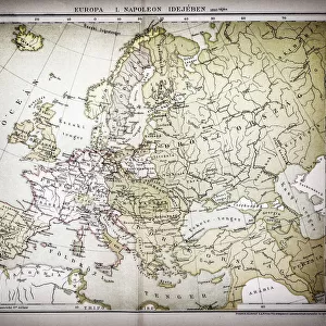
Map of Europe at the Napoleonic Wars of Liberty (1813)
")
![]()
Wall Art and Photo Gifts from Fine Art Storehouse
Map of Europe at the Napoleonic Wars of Liberty (1813)
Map of Central Europe at the beginning of the Napoleonic Wars of Liberty in 1813. Lithograph, published in 1897
Unleash your creativity and transform your space into a visual masterpiece!
Media ID 14757200
© This content is subject to copyright
Austria Baden Wurttemberg Bavaria Bohemia Brandenburg Braunschweig Burgundy Central Europe Country European Culture French Culture German Culture Hungary Liberty Lorraine Netherlands Poland Prussia Saxony Silesia Switzerland Venice Warsaw Circa 17th Century Habsburg Monarchy Multi Colored Napoleonic War Westfalia
FEATURES IN THESE COLLECTIONS
> Arts
> Landscape paintings
> Landscape art
> Landscape paintings
> Europe
> Italy
> Veneto
> Venice
> Europe
> Netherlands
> Maps
> Fine Art Storehouse
> Map
> Historical Maps
> Fine Art Storehouse
> Map
> Italian Maps
> Fine Art Storehouse
> Travel Imagery
> Travel Destinations
> Venice, Italy
EDITORS COMMENTS
This lithograph, published in 1897, showcases a historical treasure - the Map of Europe at the Napoleonic Wars of Liberty in 1813. A visual masterpiece capturing the essence of an era marked by conflict and struggle for freedom. The multi-colored landscape sprawls horizontally across the print, depicting Central Europe during this tumultuous period. The intricate details allow us to explore the diverse cultures and countries that were entangled in these wars. From Germany to France, from Austria to Poland, each region is meticulously represented with its own distinct characteristics. As our eyes wander over this historic map, we are transported back to a time when nations fought fiercely for their independence. The Rheinbund stands tall as a symbol of unity against Napoleon's forces while Saxony and Bavaria emerge as key players in this dramatic chapter of European history. The Habsburg Monarchy looms large on the canvas, reminding us of its powerful influence over vast territories including Switzerland and Bohemia. Meanwhile, Prussia asserts itself alongside Warsaw and Silesia as they navigate through turbulent times. This lithograph not only serves as a testament to past conflicts but also offers insight into French culture and German culture during this transformative period. It invites us to delve deeper into the complexities that shaped Europe's destiny. A true collector's item for history enthusiasts or anyone captivated by European heritage; it captures both the grandeur and turmoil that defined an epoch forever etched in our collective memory.
MADE IN AUSTRALIA
Safe Shipping with 30 Day Money Back Guarantee
FREE PERSONALISATION*
We are proud to offer a range of customisation features including Personalised Captions, Color Filters and Picture Zoom Tools
SECURE PAYMENTS
We happily accept a wide range of payment options so you can pay for the things you need in the way that is most convenient for you
* Options may vary by product and licensing agreement. Zoomed Pictures can be adjusted in the Cart.