Home > Europe > Italy > Veneto > Venice
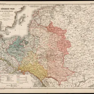
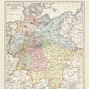
Map of Germany, after the Peace of Westphalia in 1648

![]()
Wall Art and Photo Gifts from Fine Art Storehouse
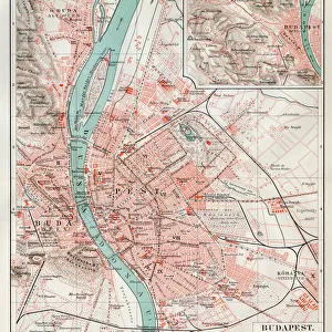
Map of Germany, after the Peace of Westphalia in 1648
Map of Germany, after the Peace of Westphalia in 1648. Lithograph, published in 1897
Unleash your creativity and transform your space into a visual masterpiece!
Media ID 14757198
© This content is subject to copyright
Austria Bavaria Bohemia Brandenburg Braunschweig Burgundy Catholicism Central Europe Conflict Confrontation Country German Culture Hungary Little Lorraine Netherlands Peace Poland Protestantism Saxony Switzerland Venice Circa 17th Century Federalism Multi Colored Peace Of Westphalia Thirty Years War Westfalia
FEATURES IN THESE COLLECTIONS
> Arts
> Landscape paintings
> Landscape art
> Landscape paintings
> Europe
> Italy
> Veneto
> Venice
> Europe
> Netherlands
> Maps
> Fine Art Storehouse
> Map
> Historical Maps
> Fine Art Storehouse
> Map
> Italian Maps
> Fine Art Storehouse
> Travel Imagery
> Travel Destinations
> Venice, Italy
> Fine Art Storehouse
> World Religion
EDITORS COMMENTS
This lithograph, published in 1897, showcases a historical treasure - the Map of Germany after the Peace of Westphalia in 1648. A true testament to the intricate artistry and attention to detail prevalent during this era, this print offers a glimpse into a significant period in German history. The map depicts Germany as it stood following the conclusion of the devastating Thirty Years War and the subsequent Peace of Westphalia. The war had ravaged Europe for three decades, tearing apart nations and leaving scars that would take years to heal. However, with peace finally achieved through diplomatic negotiations at Westphalia, a new chapter began for Germany. The map reveals not only political boundaries but also religious divisions within Germany during this time. It highlights the clash between Catholicism and Protestantism that fueled much of the conflict throughout Europe. Each region is represented by vibrant colors, showcasing its unique cultural identity amidst a backdrop of lush landscapes. From Saxony to Bavaria, Austria to Switzerland, Brandenburg to Bohemia - all these regions are meticulously illustrated on this horizontal engraving. Even neighboring countries such as France, Italy, Poland, Burgundy, Venice Hungary Lorraine Netherlands find their place on this comprehensive depiction. As we gaze upon this historic artwork today with admiration and curiosity about our pasts' complexities unfold before us; it serves as an invaluable reminder of how far we have come since those tumultuous times.
MADE IN AUSTRALIA
Safe Shipping with 30 Day Money Back Guarantee
FREE PERSONALISATION*
We are proud to offer a range of customisation features including Personalised Captions, Color Filters and Picture Zoom Tools
SECURE PAYMENTS
We happily accept a wide range of payment options so you can pay for the things you need in the way that is most convenient for you
* Options may vary by product and licensing agreement. Zoomed Pictures can be adjusted in the Cart.