Home > Europe > United Kingdom > Wales > Maps
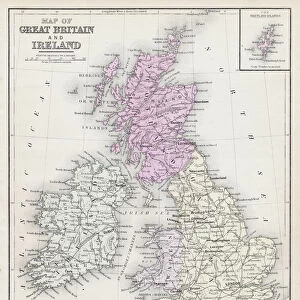
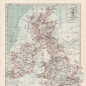
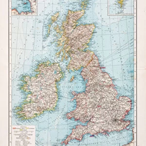
Map of Great Britain and Wales 1881

![]()
Wall Art and Photo Gifts from Fine Art Storehouse
Map of Great Britain and Wales 1881
A System of Modern Geography designed for the use of schools and academies by Augustus Mitchell - Published by T. H. Butler / Philadelphia 1881
Unleash your creativity and transform your space into a visual masterpiece!
THEPALMER
Media ID 18357211
FEATURES IN THESE COLLECTIONS
> Europe
> United Kingdom
> Wales
> Maps
> Fine Art Storehouse
> Map
> Historical Maps
> Maps and Charts
> Early Maps
> Maps and Charts
> Wales
EDITORS COMMENTS
In this photo print, we are transported back in time to the year 1881, as we explore the intricacies of a "Map of Great Britain and Wales". This remarkable piece was originally designed by Augustus Mitchell for educational purposes, specifically tailored for schools and academies. Published by T. H. Butler in Philadelphia during that era, it serves as a testament to both the artistry and functionality of cartography. The map itself is a visual feast for history enthusiasts and geography aficionados alike. Its meticulous detail showcases the diverse landscapes, rivers, cities, and towns that make up Great Britain and Wales during this pivotal period. The delicate strokes used to outline each region invite us to embark on a journey through time while admiring the craftsmanship involved in its creation. As we gaze upon this vintage masterpiece expertly captured by THEPALMER from Fine Art Storehouse, our imagination takes flight. We can almost envision students huddled around their desks in classrooms across America over a century ago, eagerly absorbing knowledge from these very maps. This print not only preserves an important historical artifact but also allows us to appreciate how far cartography has come since then. It reminds us of the enduring power of education and how something as seemingly simple as a map can shape young minds and inspire curiosity about distant lands. Whether displayed proudly on your wall or cherished within your personal collection, this stunning image offers an enchanting glimpse into both past eras and timeless geographical wonders.
MADE IN AUSTRALIA
Safe Shipping with 30 Day Money Back Guarantee
FREE PERSONALISATION*
We are proud to offer a range of customisation features including Personalised Captions, Color Filters and Picture Zoom Tools
SECURE PAYMENTS
We happily accept a wide range of payment options so you can pay for the things you need in the way that is most convenient for you
* Options may vary by product and licensing agreement. Zoomed Pictures can be adjusted in the Cart.