Home > Europe > United Kingdom > Northern Ireland > County Londonderry > Derry
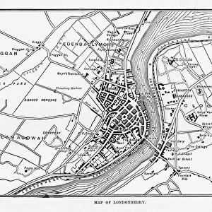
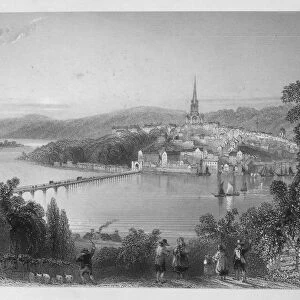
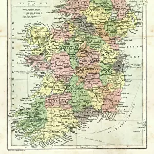
Map of Londonderry, Derry, Donegal, Northern Ireland, Victorian Engraving, 1840

![]()
Wall Art and Photo Gifts from Fine Art Storehouse
Map of Londonderry, Derry, Donegal, Northern Ireland, Victorian Engraving, 1840
Very Rare, Beautifully Illustrated Antique Engraving of Map of Londonderry, Derry, Donegal, Northern Ireland, Victorian Engraving, 1840. Source: Original edition from my own archives. Copyright has expired on this artwork. Digitally restored
Unleash your creativity and transform your space into a visual masterpiece!
bauhaus1000
Media ID 14756276
© This content is subject to copyright
FEATURES IN THESE COLLECTIONS
> Europe
> Republic of Ireland
> Maps
> Europe
> United Kingdom
> Northern Ireland
> County Londonderry
> Derry
> Europe
> United Kingdom
> Northern Ireland
> Derry
> Europe
> United Kingdom
> Northern Ireland
> Londonderry
> Europe
> United Kingdom
> Northern Ireland
> Maps
> Fine Art Storehouse
> Map
> Historical Maps
> Fine Art Storehouse
> Travel Imagery
> Travel Destinations
> Ireland
> Londonderry, Northern Ireland
> Maps and Charts
> Early Maps
EDITORS COMMENTS
This exquisite print showcases a captivating glimpse into the rich history of Londonderry, Derry, Donegal, and Northern Ireland. Dating back to 1840, this Victorian engraving is an incredibly rare find that offers a beautifully illustrated map of these enchanting regions. With its intricate details and meticulous craftsmanship, it serves as a testament to the artistic prowess of the era. The map itself provides an intriguing snapshot of the landscape during that time period. From the winding River Foyle that gracefully meanders through Londonderry's ancient walls to the lush greenery that blankets Donegal's rugged terrain, every feature is meticulously depicted with utmost precision. What makes this particular print even more special is its provenance - sourced from an original edition found within the personal archives of bauhaus1000. Its copyright has long expired on this remarkable artwork, allowing for its digital restoration and preservation for generations to come. Whether you are a history enthusiast or simply appreciate fine artistry, this print holds immense value in capturing both the geographical essence and aesthetic charm of these Irish landscapes. It serves as a window into another time while also reminding us of our connection to these storied places. Displayed proudly in any setting, it will undoubtedly spark curiosity and admiration among all who lay eyes upon it.
MADE IN AUSTRALIA
Safe Shipping with 30 Day Money Back Guarantee
FREE PERSONALISATION*
We are proud to offer a range of customisation features including Personalised Captions, Color Filters and Picture Zoom Tools
SECURE PAYMENTS
We happily accept a wide range of payment options so you can pay for the things you need in the way that is most convenient for you
* Options may vary by product and licensing agreement. Zoomed Pictures can be adjusted in the Cart.