Home > Maps and Charts > Early Maps
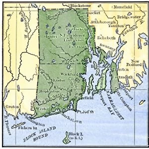
Map of the Massachusetts Bay Colony in 1676, lithograph, 1876

![]()
Wall Art and Photo Gifts from Fine Art Storehouse
Map of the Massachusetts Bay Colony in 1676, lithograph, 1876
Historical map of the Massachusetts Bay Colony in 1676. Lithograph, published in 1876
Unleash your creativity and transform your space into a visual masterpiece!
ZU_09
Media ID 21006809
FEATURES IN THESE COLLECTIONS
> Fine Art Storehouse
> Map
> Historical Maps
> Maps and Charts
> Early Maps
EDITORS COMMENTS
This lithograph, created in 1876 by the talented artist ZU_09, offers us a glimpse into the rich history of the Massachusetts Bay Colony. The map itself depicts the colony as it stood in 1676, showcasing its intricate layout and significant landmarks during that era. As we explore this historical masterpiece, we are transported back to a time when settlers were establishing their roots in this new land. The detailed cartography allows us to trace the coastline of Massachusetts Bay and observe how towns and settlements were strategically positioned along its shores. From Boston to Salem, each town is meticulously labeled, giving us insight into their importance within colonial society. The lithograph's sepia tones lend an air of antiquity to this piece, enhancing our appreciation for its historical significance. It serves as a visual testament to the determination and resilience of those who first settled these lands centuries ago. Whether you are a history enthusiast or simply captivated by artistry from times gone by, this print is sure to transport you back in time. Displayed proudly on any wall or desk space, it becomes not only a conversation starter but also a window into an important chapter of American history. ZU_09's skillful rendering brings life and depth to this map; every line tells a story waiting to be discovered. Immerse yourself in the past with this remarkable lithograph – an exquisite addition for any lover of both art and history alike.
MADE IN AUSTRALIA
Safe Shipping with 30 Day Money Back Guarantee
FREE PERSONALISATION*
We are proud to offer a range of customisation features including Personalised Captions, Color Filters and Picture Zoom Tools
SECURE PAYMENTS
We happily accept a wide range of payment options so you can pay for the things you need in the way that is most convenient for you
* Options may vary by product and licensing agreement. Zoomed Pictures can be adjusted in the Cart.