Home > North America > Mexico > Maps
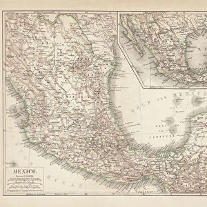
Map of Mexico Caribbean Central America 1898

![]()
Wall Art and Photo Gifts from Fine Art Storehouse
Map of Mexico Caribbean Central America 1898
Unleash your creativity and transform your space into a visual masterpiece!
THEPALMER
Media ID 14756980
© This content is subject to copyright
FEATURES IN THESE COLLECTIONS
> Fine Art Storehouse
> Map
> Historical Maps
> Maps and Charts
> Early Maps
> North America
> Mexico
> Maps
EDITORS COMMENTS
This print titled "Map of Mexico Caribbean Central America 1898" takes us on a journey back in time to the late 19th century. The intricate details and vibrant colors of this historical map transport us to an era when cartography was both art and science. The map, created by THEPALMER, showcases the geographical beauty of Mexico, the Caribbean islands, and Central America during this period. It serves as a visual testament to the rich history and cultural diversity that shaped these regions. As we gaze upon this piece, our eyes are drawn to every corner where cities, rivers, mountains, and coastlines come alive with remarkable precision. The careful craftsmanship reminds us of a time when maps were meticulously hand-drawn with utmost dedication. Beyond its aesthetic appeal lies a deeper appreciation for the significance of this map. It offers valuable insights into political boundaries, trade routes, and colonial influences that played pivotal roles in shaping these lands over centuries. Whether displayed in a home library or an educational institution's walls, this print from Fine Art Storehouse is sure to spark curiosity among admirers who seek knowledge about our world's past. Its presence invites exploration into forgotten stories waiting to be uncovered. In essence, "Map of Mexico Caribbean Central America 1898" encapsulates not only geographic information but also represents an artistic masterpiece that connects us with our shared heritage.
MADE IN AUSTRALIA
Safe Shipping with 30 Day Money Back Guarantee
FREE PERSONALISATION*
We are proud to offer a range of customisation features including Personalised Captions, Color Filters and Picture Zoom Tools
SECURE PAYMENTS
We happily accept a wide range of payment options so you can pay for the things you need in the way that is most convenient for you
* Options may vary by product and licensing agreement. Zoomed Pictures can be adjusted in the Cart.