Home > Maps and Charts > Early Maps
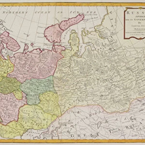
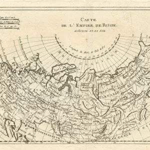
Map of the Russian Empire 18th century 1778

![]()
Wall Art and Photo Gifts from Fine Art Storehouse
Map of the Russian Empire 18th century 1778
This is an historical 18th century copperplate engraving, a map of the Russian Empire as it was in 1778. Captions: Engraved for Middletons Complete System of Geography. An Accurate MAP of the RUSSIAN EMPIRE as contained in EUROPE and ASIA. Drawn from the best Authorities By Thomas Bowen 1778
Unleash your creativity and transform your space into a visual masterpiece!
Whiteway
Media ID 14757178
© Whiteway
FEATURES IN THESE COLLECTIONS
> Asia
> Related Images
> Europe
> Related Images
> Fine Art Storehouse
> Map
> Historical Maps
> Maps and Charts
> Early Maps
EDITORS COMMENTS
This print showcases a remarkable piece of history - an 18th-century copperplate engraving depicting the Map of the Russian Empire in 1778. The intricate details and exquisite craftsmanship make this artwork truly exceptional. Engraved specifically for Middletons Complete System of Geography, this map offers a comprehensive view of the vast Russian Empire as it spanned across both Europe and Asia during that era. Renowned cartographer Thomas Bowen meticulously drew upon the best available sources to create an accurate representation. The map's significance lies not only in its historical value but also in its ability to transport us back to a time when empires reigned supreme and boundaries were constantly shifting. It serves as a visual testament to Russia's expansive territorial reach, showcasing its influence over diverse regions. Whiteway's expertly captured photograph allows us to appreciate every minute detail, from the delicate lines tracing rivers and mountain ranges to the precise labeling of cities and provinces. This print is more than just an artistic masterpiece; it is a window into our past, offering insights into geopolitical dynamics and cultural landscapes that have shaped our world today. Whether you are an avid history enthusiast or simply appreciate fine art, this print will undoubtedly add depth and intrigue to any space it graces. Let yourself be transported through time with this stunning portrayal of the Russian Empire at its height in 1778.
MADE IN AUSTRALIA
Safe Shipping with 30 Day Money Back Guarantee
FREE PERSONALISATION*
We are proud to offer a range of customisation features including Personalised Captions, Color Filters and Picture Zoom Tools
SECURE PAYMENTS
We happily accept a wide range of payment options so you can pay for the things you need in the way that is most convenient for you
* Options may vary by product and licensing agreement. Zoomed Pictures can be adjusted in the Cart.