Home > Arts > Landscape paintings > Landscape art > Landscape paintings
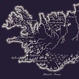
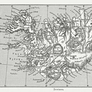
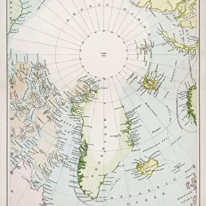
Map of Volcanic Chart of Iceland Engraving

![]()
Wall Art and Photo Gifts from Fine Art Storehouse
Map of Volcanic Chart of Iceland Engraving
Engraved Illustrations of Volcanoes and Volcanic Formations and Stratification and the Map of Volcanic Chart of Iceland from Iconographic Encyclopedia of Science, Literature and Art, Published in 1851. Copyright has expired on this artwork. Digitally restored
Unleash your creativity and transform your space into a visual masterpiece!
bauhaus1000
Media ID 13666741
© Craig McCausland
1860 1869 66695 78279 Arrangement Art Product Chart Diagram Drypoint Geology Iceland Image Created 1860 1869 Plan Rock Strata Topography Volcanic Landscape Volcano Image Created 19th Century Stratification
FEATURES IN THESE COLLECTIONS
> Arts
> Landscape paintings
> Landscape art
> Landscape paintings
> Arts
> Literature
> Illustration
> Arts
> Literature
> Fine Art Storehouse
> Map
> Historical Maps
> Maps and Charts
> Early Maps
EDITORS COMMENTS
This print showcases the "Map of Volcanic Chart of Iceland Engraving" from the renowned Iconographic Encyclopedia of Science, Literature and Art, originally published in 1851. With its copyright expired, this digitally restored artwork takes us back to the 19th century when scientific exploration and artistic craftsmanship merged seamlessly. The intricate details of this woodcut engraving highlight the awe-inspiring beauty and geological complexity of Iceland's volcanic landscape. From majestic mountains to mesmerizing rock strata, every element is meticulously captured through etching and drypoint techniques. The arrangement of this chart provides a comprehensive understanding of Iceland's topography, offering a glimpse into its rich history. As we delve into this artful representation, we are transported to an era where science met artistry with precision and elegance. This print serves as a testament to human curiosity about our physical world and the desire to document it artistically. Whether you are an enthusiast for cartography or simply appreciate the fusion between science and art, this historical artifact offers a unique window into Iceland's volcanic wonders. Let your imagination wander as you explore each contour on this map – envisioning ancient eruptions that shaped landscapes still admired today. Preserved for generations to come, "Map of Volcanic Chart of Iceland Engraving" invites us on a visual journey through time while celebrating both natural phenomena and artistic ingenuity from centuries past.
MADE IN AUSTRALIA
Safe Shipping with 30 Day Money Back Guarantee
FREE PERSONALISATION*
We are proud to offer a range of customisation features including Personalised Captions, Color Filters and Picture Zoom Tools
SECURE PAYMENTS
We happily accept a wide range of payment options so you can pay for the things you need in the way that is most convenient for you
* Options may vary by product and licensing agreement. Zoomed Pictures can be adjusted in the Cart.