Home > North America > Mexico > Maps
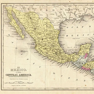
Mexico map 1897

![]()
Wall Art and Photo Gifts from Fine Art Storehouse
Mexico map 1897
The World-Wide Atlas of Modern Geography, Political and Physical W. & A.K. Johnston - London 1897
Unleash your creativity and transform your space into a visual masterpiece!
THEPALMER
Media ID 14757108
© Roberto A Sanchez
Atlantic Ocean Atlas Backgrounds Burnt Caribbean Caribbean Sea Country Geographic Area Direction Earth Grunge Mexico North North America Pacific Ocean Paper Patina Rusty Sepia Toned Textured Effect World Map Retro Styled
FEATURES IN THESE COLLECTIONS
> Europe
> United Kingdom
> England
> London
> Related Images
> Fine Art Storehouse
> Map
> Historical Maps
> Fine Art Storehouse
> Map
> USA Maps
> Maps and Charts
> Early Maps
> Maps and Charts
> World
> North America
> Mexico
> Maps
> North America
> United States of America
> Maps
EDITORS COMMENTS
This print takes us back in time to the year 1897, when cartography was a meticulous art form. The Mexico map featured here is an exquisite piece from "The World-Wide Atlas of Modern Geography" created by W. & A. K. Johnston in London. With its retro styling and antique charm, this engraved image showcases the intricate details that were once painstakingly etched onto paper. The burnt backgrounds and textured effect give this map a rustic appeal, evoking a sense of history and authenticity. Sepia tones add to its vintage allure while highlighting the country's geographic area within North America, bordered by the United States to the north and surrounded by both the Pacific Ocean and Caribbean Sea. As we gaze upon this old-world treasure, we are reminded of how far our understanding of physical geography has come since 1897. The grunge patina on this map serves as a reminder of all those who have studied it over generations past. "The Mexico Map 1897" invites us to explore not only the boundaries of countries but also our own curiosity about Earth's diverse landscapes. It reminds us that even though time may weather paper maps like these, their beauty endures for generations to come.
MADE IN AUSTRALIA
Safe Shipping with 30 Day Money Back Guarantee
FREE PERSONALISATION*
We are proud to offer a range of customisation features including Personalised Captions, Color Filters and Picture Zoom Tools
SECURE PAYMENTS
We happily accept a wide range of payment options so you can pay for the things you need in the way that is most convenient for you
* Options may vary by product and licensing agreement. Zoomed Pictures can be adjusted in the Cart.