Home > North America > United States of America > Lakes > Lake Huron
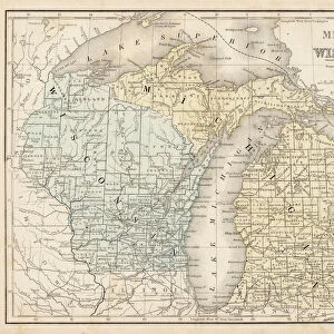
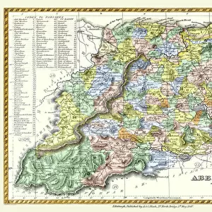
Michigan 1852 Map

![]()
Wall Art and Photo Gifts from Fine Art Storehouse
Michigan 1852 Map
Unleash your creativity and transform your space into a visual masterpiece!
benoitb
Media ID 13666901
© benoitb
Color Swatch Geographic Map Great Lakes Lake Erie Lake Michigan Lake Superior Line Art Michigan North America Sketch State The Americas Us State Border Classical Style Drawing Art Product Lake Huron Painted Image Retro Styled Victorian Style
FEATURES IN THESE COLLECTIONS
> Arts
> Landscape paintings
> Waterfall and river artworks
> River artworks
> Fine Art Storehouse
> Map
> Historical Maps
> Fine Art Storehouse
> Map
> USA Maps
> Maps and Charts
> Early Maps
> North America
> United States of America
> Lakes
> Lake Erie
> North America
> United States of America
> Lakes
> Lake Huron
> North America
> United States of America
> Lakes
> Lake Michigan
> North America
> United States of America
> Lakes
> Lake Superior
> North America
> United States of America
> Maps
> North America
> United States of America
> Michigan
> Related Images
EDITORS COMMENTS
This print takes us back in time to the year 1852, immersing us in the rich history of Michigan. With its retro-styled and 19th-century aesthetic, this cartographic masterpiece showcases the state's intricate physical geography with remarkable detail. The artist skillfully combines elements of painted images, sketches, and line art to create an antique engraved image that exudes a sense of classical Victorian style. The color swatches add depth and vibrancy to the illustration while maintaining an authentic feel. As we gaze upon this artwork, our eyes are drawn to the majestic Great Lakes - Huron, Erie, Superior, and Michigan - which dominate the composition. These vast bodies of water played a crucial role in shaping Michigan's identity as they provided transportation routes for trade and exploration during that era. Every river meandering through Michigan is meticulously depicted on this map—each one representing a lifeline for communities scattered across the state. The borders delineating Michigan from neighboring states remind us of its place within North America. Benoitb's drawing art product beautifully captures not only geographical accuracy but also evokes a sense of nostalgia for bygone times. This print serves as a testament to both artistic craftsmanship and historical significance—a true homage to Michigan's past.
MADE IN AUSTRALIA
Safe Shipping with 30 Day Money Back Guarantee
FREE PERSONALISATION*
We are proud to offer a range of customisation features including Personalised Captions, Color Filters and Picture Zoom Tools
SECURE PAYMENTS
We happily accept a wide range of payment options so you can pay for the things you need in the way that is most convenient for you
* Options may vary by product and licensing agreement. Zoomed Pictures can be adjusted in the Cart.