Home > Europe > United Kingdom > England > Hampshire > Canada
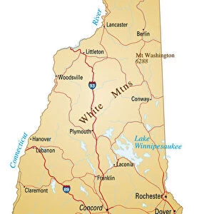
New Hampshire 1852 Map

![]()
Wall Art and Photo Gifts from Fine Art Storehouse
New Hampshire 1852 Map
Unleash your creativity and transform your space into a visual masterpiece!
benoitb
Media ID 13666929
© benoitb
Atlantic Ocean Canada Color Swatch Geographic Map Line Art Maine New Hampshire Sketch State The Americas Vermont Classical Style Drawing Art Product Painted Image Retro Styled Victorian Style
FEATURES IN THESE COLLECTIONS
> Arts
> Landscape paintings
> Waterfall and river artworks
> River artworks
> Europe
> France
> Canton
> Maine
> Europe
> United Kingdom
> England
> Hampshire
> Canada
> Fine Art Storehouse
> Map
> Historical Maps
> Fine Art Storehouse
> Map
> USA Maps
> Maps and Charts
> Early Maps
> North America
> Canada
> Lakes
> Related Images
> North America
> Canada
> Maps
> North America
> United States of America
> Lakes
> Related Images
> North America
> United States of America
> Maine
> Related Images
> North America
> United States of America
> Maps
EDITORS COMMENTS
This print takes us back in time to the year 1852, showcasing a meticulously detailed map of New Hampshire. The artist has skillfully captured the essence of cartography from the 19th century, employing a retro style that evokes feelings of nostalgia and admiration for this bygone era. The image is presented as a painted illustration, reminiscent of an antique engraved image or sketch. Its classical Victorian style transports us to a different time, where physical geography was beautifully depicted through artistry and precision. The map encompasses not only New Hampshire but also neighboring states such as Vermont and Maine. Stretching beyond national borders, it extends into Canada and other parts of the Americas. The vastness of the Atlantic Ocean serves as a striking backdrop while various lakes and rivers meander across the landscape. Every detail on this engraving has been carefully crafted, from intricate line art to vibrant color swatches that bring life to each region portrayed. This drawing art product truly captures the essence of history with its old-world charm. Benoitb's print offers viewers an opportunity to appreciate both the artistic craftsmanship involved in creating such maps during that period and gain insight into how these regions were perceived over 150 years ago. It is undoubtedly an exquisite piece that would make a valuable addition to any collection celebrating both art and geography enthusiasts alike.
MADE IN AUSTRALIA
Safe Shipping with 30 Day Money Back Guarantee
FREE PERSONALISATION*
We are proud to offer a range of customisation features including Personalised Captions, Color Filters and Picture Zoom Tools
SECURE PAYMENTS
We happily accept a wide range of payment options so you can pay for the things you need in the way that is most convenient for you
* Options may vary by product and licensing agreement. Zoomed Pictures can be adjusted in the Cart.