Home > North America > United States of America > New York > New York > Maps
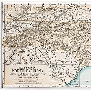
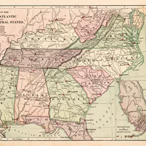
North Carolina map 1884

![]()
Wall Art and Photo Gifts from Fine Art Storehouse
North Carolina map 1884
Encyclopedia Britannica 9th Edition New York Charles Scribners and Sonsl 1884 Vol XVII
Unleash your creativity and transform your space into a visual masterpiece!
THEPALMER
Media ID 14756670
© This content is subject to copyright
North Carolina South Carolina State
FEATURES IN THESE COLLECTIONS
> Fine Art Storehouse
> Map
> Historical Maps
> Fine Art Storehouse
> Map
> USA Maps
> Maps and Charts
> Early Maps
> North America
> United States of America
> Maps
> North America
> United States of America
> New York
> New York
> Maps
> North America
> United States of America
> North Carolina
> Related Images
> North America
> United States of America
> South Carolina
> Related Images
EDITORS COMMENTS
In this photo print, titled "North Carolina Map 1884" we are transported back in time to the late 19th century. The image showcases a beautifully detailed map from the Encyclopedia Britannica's 9th Edition, published in New York by Charles Scribners and Sons in 1884. The map itself is a testament to both artistry and cartographic precision. Every intricate detail of North Carolina, South Carolina, and surrounding states is meticulously depicted, offering us a glimpse into the geographical landscape of that era. From the sprawling coastlines to the majestic Appalachian Mountains, this vintage map captures the essence of these southern states with remarkable accuracy. As we admire this historical piece created by THEPALMER for Fine Art Storehouse, it serves as a reminder of how far our understanding of geography has come over time. It sparks curiosity about what life was like during that period - when horse-drawn carriages traversed dirt roads instead of highways bustling with cars. This photograph print not only appeals to history enthusiasts but also adds an elegant touch to any space it graces. Whether displayed in a home library or office setting, its timeless charm invites viewers on a journey through America's past while simultaneously celebrating the beauty found within maps themselves. Through "North Carolina Map 1884". THEPALMER skillfully combines nostalgia and artistic craftsmanship to create an exquisite piece that will undoubtedly captivate admirers for years to come.
MADE IN AUSTRALIA
Safe Shipping with 30 Day Money Back Guarantee
FREE PERSONALISATION*
We are proud to offer a range of customisation features including Personalised Captions, Color Filters and Picture Zoom Tools
SECURE PAYMENTS
We happily accept a wide range of payment options so you can pay for the things you need in the way that is most convenient for you
* Options may vary by product and licensing agreement. Zoomed Pictures can be adjusted in the Cart.