Home > Arts > Minimalist artwork > Monochrome artwork > Black and white artwork
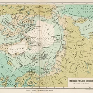
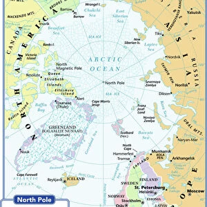
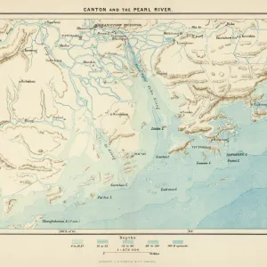
Victorian map of the Arctic Circle

![]()
Wall Art and Photo Gifts from Fine Art Storehouse
Victorian map of the Arctic Circle
A Victorian map of the Arctic Circle and beyond. From Peter Parleyas Annual - A Christmas and New Yearas Present for Young Peoplea published in London by Darton & Co in 1851
Unleash your creativity and transform your space into a visual masterpiece!
Linda Steward
Media ID 13667237
© Linda Steward
62990 78279 Arctic Atlantic Ocean Circle Continent Country Geographic Area Direction Directly Above Earth Education Empire Globe Navigational Equipment Latitude Line Art Longitude Memories Monochrome Navigational Equipment North America Nostalgia Pacific Ocean Sepia Toned Social History The Americas China East Asia Chinese Empire Image Created 19th Century Russian Empire Victorian Style
FEATURES IN THESE COLLECTIONS
> Animals
> Mammals
> Cats (Domestic)
> Russian White
> Arts
> Artists
> P
> those present
> Arts
> Minimalist artwork
> Monochrome artwork
> Black and white artwork
> Arts
> Minimalist artwork
> Monochrome artwork
> Fine art
> Arts
> Minimalist artwork
> Monochrome artwork
> Monochrome paintings
> Europe
> Related Images
> Fine Art Storehouse
> Map
> Historical Maps
> Fine Art Storehouse
> Photo Libraries
> The Illustrated London News (ILN)
> Maps and Charts
> Early Maps
EDITORS COMMENTS
This print takes us back in time to the 19th century, immersing us in the rich history and exploration of the Arctic Circle. The Victorian map, meticulously engraved with fine lines and presented in monochrome, offers a glimpse into an era when navigational equipment was still evolving. As we gaze upon this sepia-toned image, we are transported to a world where continents were vast and uncharted territories awaited discovery. The map stretches across Asia, Europe, North America, and beyond – reminding us of the interconnectedness of cultures during that period. The detailed depiction of longitude and latitude lines serves as a reminder of how early cartographers strived to accurately represent our planet's geography. It also highlights the importance placed on education during Victorian times. The Arctic Circle itself is at the heart of this illustration; its icy expanse symbolizing both mystery and danger. Surrounding it are vast oceans - the Pacific Ocean to one side and the Atlantic Ocean on another - emphasizing humanity's fascination with conquering new frontiers. Intriguingly, this map includes references to various empires such as China's Chinese Empire and Russia's Russian Empire – showcasing geopolitical dynamics prevalent at that time. Linda Steward skillfully captures nostalgia for bygone eras through her use of 19th-century style. This print invites viewers to reflect on memories from long ago while appreciating how far we have come in terms of geographic knowledge since then.
MADE IN AUSTRALIA
Safe Shipping with 30 Day Money Back Guarantee
FREE PERSONALISATION*
We are proud to offer a range of customisation features including Personalised Captions, Color Filters and Picture Zoom Tools
SECURE PAYMENTS
We happily accept a wide range of payment options so you can pay for the things you need in the way that is most convenient for you
* Options may vary by product and licensing agreement. Zoomed Pictures can be adjusted in the Cart.