Home > North America > Greenland > Maps
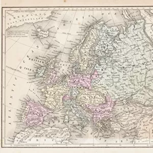
Victorian map of the North Polar Regions

![]()
Wall Art and Photo Gifts from Fine Art Storehouse
Victorian map of the North Polar Regions
Vintage engraving showing a Victorian map of the North Polar Regions
Unleash your creativity and transform your space into a visual masterpiece!
duncan1890
Media ID 13666959
© duncan1890
78279 Arctic Greenland Navigational Equipment Nordic Countries North North America North Pole Northern Europe Russia Scandinavia Styles Sweden Image Created 19th Century Nautical Chart Obsolete Retro Styled Victorian Style
FEATURES IN THESE COLLECTIONS
> Fine Art Storehouse
> Map
> Historical Maps
> Maps and Charts
> Early Maps
> North America
> Greenland
> Maps
EDITORS COMMENTS
This vintage engraving transports us back to the 19th century, showcasing a meticulously detailed Victorian map of the North Polar Regions. With its retro styling and antique charm, this engraved image evokes a sense of nostalgia for a bygone era of cartography. The woodcut illustration, created in the 19th century, captures the essence of an obsolete navigational chart. Its black and white composition adds to its historical allure while highlighting the intricate details that make up this fascinating piece. The print showcases not only the Nordic countries but also Russia, Sweden, Scandinavia, Greenland, and Northern Europe. Immersed in history and steeped in Victorian style, this print serves as a window into the past. It reminds us of how far we have come in our understanding of these regions while paying homage to early explorers who ventured into uncharted territories. As we gaze upon this vertical artwork devoid of people or modern influences, it sparks curiosity about what life was like during that time. It invites us to explore further into our own imaginations and contemplate how different things were centuries ago. Duncan1890's photography skillfully captures every detail with precision and reverence for history. This print is not just an image; it is a testament to human exploration and discovery—a tangible reminder of our collective journey through time.
MADE IN AUSTRALIA
Safe Shipping with 30 Day Money Back Guarantee
FREE PERSONALISATION*
We are proud to offer a range of customisation features including Personalised Captions, Color Filters and Picture Zoom Tools
SECURE PAYMENTS
We happily accept a wide range of payment options so you can pay for the things you need in the way that is most convenient for you
* Options may vary by product and licensing agreement. Zoomed Pictures can be adjusted in the Cart.