Home > North America > United States of America > New York > New York > Maps
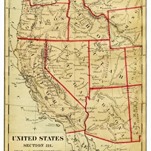
World map 1867

![]()
Wall Art and Photo Gifts from Fine Art Storehouse
World map 1867
Guyots Geographical Series The Earth and its inhabitants 1867 New York
Unleash your creativity and transform your space into a visual masterpiece!
THEPALMER
Media ID 14756954
© This content is subject to copyright
FEATURES IN THESE COLLECTIONS
> Fine Art Storehouse
> Map
> Historical Maps
> Maps and Charts
> Early Maps
> Maps and Charts
> World
> North America
> United States of America
> New York
> New York
> Maps
EDITORS COMMENTS
This print titled "World map 1867 (Guyots Geographical Series The Earth and its inhabitants 1867 New York)" takes us on a mesmerizing journey back in time. Created by THEPALMER, this piece is a testament to the intricate artistry and historical significance of cartography. The image showcases an intricately detailed world map from the year 1867, extracted from Guyots Geographical Series, which was published in New York during that era. As we gaze upon it, we are transported to a time when exploration and discovery were at their peak. The fine lines and delicate shading bring each continent, ocean, and landmass to life with remarkable precision. This particular print captures not only the geographical aspects but also offers insights into the cultural diversity of our planet during that period. It serves as a visual representation of how people perceived the world over a century ago – highlighting borders that have since shifted or disappeared altogether. THEPALMER's attention to detail allows us to appreciate both the artistic beauty and educational value of this vintage masterpiece. Whether you're an avid history enthusiast or simply captivated by maps' allure, this print is sure to ignite your imagination while providing an intriguing glimpse into our past. Displaying "World map 1867" in your home or office will undoubtedly spark conversations about global exploration, historical context, and human progress throughout centuries. This artwork stands as a timeless reminder of our ever-evolving understanding of Earth's vastness—a true treasure for any
MADE IN AUSTRALIA
Safe Shipping with 30 Day Money Back Guarantee
FREE PERSONALISATION*
We are proud to offer a range of customisation features including Personalised Captions, Color Filters and Picture Zoom Tools
SECURE PAYMENTS
We happily accept a wide range of payment options so you can pay for the things you need in the way that is most convenient for you
* Options may vary by product and licensing agreement. Zoomed Pictures can be adjusted in the Cart.