Home > Africa > Benin > Maps
Canvas Print : Map of Nigeria


![]()
Canvas Prints from Fine Art Storehouse
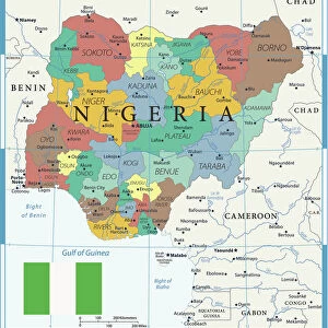
Map of Nigeria
Nigeria is a country on the coast of West Africa, bordered in south by the Bight of Benin and the Bight of Biafra (Bight of Bonny), both part of the Gulf of Guinea, by Niger in north, Benin in west, Cameroon in south east, and by Chad in north east by a boundary across Lake Chad. The nation shares maritime borders with Equatorial Guinea, Ghana, and S├úo Tom├® and Pr├¡ncipe
Unleash your creativity and transform your space into a visual masterpiece!
Media ID 20251041
20"x16" (51x41cm) Canvas Print
Discover the beauty and rich history of Nigeria with our exquisite Canvas Prints from Media Storehouse's Fine Art Storehouse collection. Each print showcases a stunning and intricate Map of Nigeria, meticulously rendered in vivid colors and detailed textures. Perfect for adding a touch of global flair to any room in your home or office, these canvas prints are not only a beautiful decorative addition but also a thoughtful and unique gift for travel enthusiasts, history buffs, or anyone with a connection to or appreciation for the diverse culture and heritage of West Africa.
Delivered stretched and ready to hang our premium quality canvas prints are made from a polyester/cotton blend canvas and stretched over a 1.25" (32mm) kiln dried knot free wood stretcher bar. Packaged in a plastic bag and secured to a cardboard insert for safe transit.
Canvas Prints add colour, depth and texture to any space. Professionally Stretched Canvas over a hidden Wooden Box Frame and Ready to Hang
Estimated Product Size is 40.6cm x 50.8cm (16" x 20")
These are individually made so all sizes are approximate
Artwork printed orientated as per the preview above, with portrait (vertical) orientation to match the source image.
FEATURES IN THESE COLLECTIONS
> Africa
> Benin
> Related Images
> Africa
> Cameroon
> Lakes
> Related Images
> Africa
> Cameroon
> Related Images
> Africa
> Chad
> Lakes
> Lake Chad
> Africa
> Chad
> Lakes
> Related Images
> Africa
> Chad
> Related Images
> Africa
> Equatorial Guinea
> Maps
> Africa
> Equatorial Guinea
> Related Images
EDITORS COMMENTS
This stunning print showcases the intricate and diverse geography of Nigeria, a vibrant country located on the coast of West Africa. The map beautifully depicts Nigeria's borders, with the Bight of Benin and the Bight of Biafra (Bight of Bonny) gracing its southern coastline as part of the Gulf of Guinea. To the north lies Niger, while Benin rests to its west. In the southeast, Cameroon shares a border with Nigeria, and in the northeast, Chad is separated by a boundary that stretches across Lake Chad. Nigeria's rich cultural heritage and natural beauty are perfectly encapsulated in this image. As one gazes upon it, they can almost feel themselves immersed in Nigeria's bustling cities, picturesque landscapes, and vibrant communities. This print not only serves as an educational tool but also evokes a sense of wanderlust for those who have yet to explore this remarkable nation. With maritime borders shared with Equatorial Guinea, Ghana, S├úo Tom├® and Pr├¡ncipe islands further enhance Nigeria's connection to neighboring countries within Africa. Whether displayed in classrooms or homes around the world, this print is sure to spark curiosity about Nigeria's history and allure visitors towards discovering its hidden treasures firsthand.
MADE IN AUSTRALIA
Safe Shipping with 30 Day Money Back Guarantee
FREE PERSONALISATION*
We are proud to offer a range of customisation features including Personalised Captions, Color Filters and Picture Zoom Tools
SECURE PAYMENTS
We happily accept a wide range of payment options so you can pay for the things you need in the way that is most convenient for you
* Options may vary by product and licensing agreement. Zoomed Pictures can be adjusted in the Cart.