Home > Africa > Djibouti > Maps
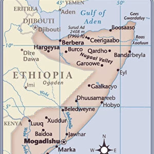
Djibouti country map

![]()
Wall Art and Photo Gifts from Fine Art Storehouse
Djibouti country map
2011 edition
Unleash your creativity and transform your space into a visual masterpiece!
Media ID 14432071
FEATURES IN THESE COLLECTIONS
> Africa
> Djibouti
> Related Images
> Fine Art Storehouse
> Map
> Reference Maps
> Maps and Charts
> Related Images
EDITORS COMMENTS
This print showcases the Djibouti country map, specifically the 2011 edition. With intricate details and vibrant colors, it offers a visually stunning representation of this East African nation. The map highlights various geographical features, including mountains, rivers, and coastlines that define Djibouti's unique landscape. The composition of this artwork is truly remarkable; every contour and boundary has been meticulously captured to provide an accurate depiction of the country's topography. From afar, one can appreciate the overall shape of Djibouti as it sits strategically at the entrance to the Red Sea. As we delve deeper into this image, our eyes are drawn to specific landmarks such as Lake Assal - a mesmerizing saltwater lake known for its striking turquoise hue. We can also spot iconic cities like Djibouti City with its bustling port and urban sprawl. Beyond its aesthetic appeal, this print serves as more than just a decorative piece; it invites us to explore and learn about Djibouti's rich history and cultural heritage. Whether you have personal ties to this fascinating nation or simply possess an affinity for cartography, this artwork will undoubtedly spark conversations and ignite curiosity about one of Africa's hidden gems.
MADE IN AUSTRALIA
Safe Shipping with 30 Day Money Back Guarantee
FREE PERSONALISATION*
We are proud to offer a range of customisation features including Personalised Captions, Color Filters and Picture Zoom Tools
SECURE PAYMENTS
We happily accept a wide range of payment options so you can pay for the things you need in the way that is most convenient for you
* Options may vary by product and licensing agreement. Zoomed Pictures can be adjusted in the Cart.