Home > North America > United States of America > North Dakota > Bismarck
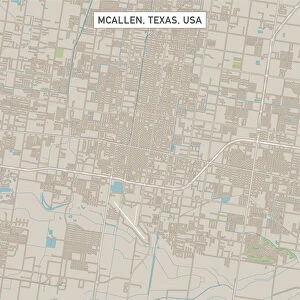
Bismarck North Dakota US City Street Map

![]()
Wall Art and Photo Gifts from Fine Art Storehouse
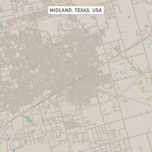
Bismarck North Dakota US City Street Map
Vector Illustration of a City Street Map of Bismarck, North Dakota, USA. Scale 1:60, 000.
All source data is in the public domain.
U.S. Geological Survey, US Topo
Used Layers:
USGS The National Map: National Hydrography Dataset (NHD)
USGS The National Map: National Transportation Dataset (NTD)
Unleash your creativity and transform your space into a visual masterpiece!
Frank Ramspott
Media ID 15215820
© Frank Ramspott, all rights reserved
Aerial View City Map Computer Graphic Directly Above Downtown District Gray North Dakota Road Map Text Bismarck Digitally Generated Image Green Color Missouri River White Color
FEATURES IN THESE COLLECTIONS
> Aerial Photography
> Related Images
> Animals
> Insects
> Hemiptera
> Green Scale
> Arts
> Landscape paintings
> Waterfall and river artworks
> River artworks
> Arts
> Portraits
> Pop art gallery
> Street art portraits
> Fine Art Storehouse
> Map
> Street Maps
> Fine Art Storehouse
> Map
> USA Maps
> Maps and Charts
> Geological Map
> North America
> United States of America
> Lakes
> Related Images
> North America
> United States of America
> Maps
> North America
> United States of America
> Missouri
> Related Images
> North America
> United States of America
> North Dakota
> Bismarck
EDITORS COMMENTS
This print showcases a meticulously detailed city street map of Bismarck, North Dakota, USA. The vector illustration presents an aerial view of the city, highlighting its intricate road network and various landmarks. With a scale of 1:60,000, this artwork provides an accurate representation of the city's layout. The source data used for creating this masterpiece is in the public domain and comes from reputable sources such as the U. S. Geological Survey (USGS) and their National Map projects. Layers from USGS' National Hydrography Dataset (NHD) and National Transportation Dataset (NTD) were utilized to ensure precision in depicting water bodies like the Missouri River, downtown district areas, lakes, rivers, streets, roads, and other essential features. Designed by Frank Ramspott using computer graphics techniques, this digitally generated image boasts vibrant colors including shades of gray for text details alongside blue hues representing water bodies and white color symbolizing urban areas. Additionally, green accents add a touch of nature to the overall composition. Perfectly suited for enthusiasts of cartography or those with an affinity for Bismarck's geography and urban planning aesthetics alike; this print offers a visually appealing way to explore the city's intricacies without any human presence obstructing your view. Whether you're seeking inspiration or simply appreciate fine art that celebrates physical geography through modern design elements - this piece is sure to captivate your imagination.
MADE IN AUSTRALIA
Safe Shipping with 30 Day Money Back Guarantee
FREE PERSONALISATION*
We are proud to offer a range of customisation features including Personalised Captions, Color Filters and Picture Zoom Tools
SECURE PAYMENTS
We happily accept a wide range of payment options so you can pay for the things you need in the way that is most convenient for you
* Options may vary by product and licensing agreement. Zoomed Pictures can be adjusted in the Cart.