Home > Animals > Insects > Hemiptera > Green Scale
Kent Washington US City Street Map

![]()
Wall Art and Photo Gifts from Fine Art Storehouse
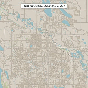
Kent Washington US City Street Map
Vector Illustration of a City Street Map of Kent, Washington, USA. Scale 1:60, 000.
All source data is in the public domain.
U.S. Geological Survey, US Topo
Used Layers:
USGS The National Map: National Hydrography Dataset (NHD)
USGS The National Map: National Transportation Dataset (NTD)
Unleash your creativity and transform your space into a visual masterpiece!
Frank Ramspott
Media ID 15054993
© Frank Ramspott, all rights reserved
Aerial View City Map Computer Graphic Directly Above Downtown District Gray Kent Road Map Text Washington State Digitally Generated Image Green Color White Color
FEATURES IN THESE COLLECTIONS
> Aerial Photography
> Related Images
> Animals
> Insects
> Hemiptera
> Green Scale
> Arts
> Landscape paintings
> Waterfall and river artworks
> River artworks
> Arts
> Portraits
> Pop art gallery
> Street art portraits
> Fine Art Storehouse
> Map
> Street Maps
> Fine Art Storehouse
> Map
> USA Maps
> Maps and Charts
> Geological Map
> North America
> United States of America
> Lakes
> Related Images
> North America
> United States of America
> Maps
> North America
> United States of America
> Washington, District of Columbia
> North America
> United States of America
> Washington
> Related Images
EDITORS COMMENTS
This print showcases a meticulously detailed city street map of Kent, Washington, USA. The vector illustration captures the essence of this vibrant city with its downtown district, serene lake, and winding river. With a scale of 1:60,000, every road and street is intricately depicted in this digitally generated image. The artist behind this masterpiece is Frank Ramspott who skillfully utilized various layers from the USGS The National Map to create this visually stunning cartographic design. By incorporating data from the National Hydrography Dataset (NHD) and the National Transportation Dataset (NTD), Ramspott has crafted an accurate representation of Kent's physical geography. In shades of gray, blue, white, and green colors against a backdrop of textural elements, this aerial view offers a unique perspective on the city's layout. This print serves as both an informative tool for navigation enthusiasts and a striking piece of art that can enhance any space. With no people present in the image itself but rather focusing solely on the urban landscape, it encapsulates Kent's charm while leaving room for personal interpretation. As part of Fine Art Storehouse's collection featuring public domain works by talented artists like Frank Ramspott, this print promises to captivate viewers with its intricate details and artistic flair.
MADE IN AUSTRALIA
Safe Shipping with 30 Day Money Back Guarantee
FREE PERSONALISATION*
We are proud to offer a range of customisation features including Personalised Captions, Color Filters and Picture Zoom Tools
SECURE PAYMENTS
We happily accept a wide range of payment options so you can pay for the things you need in the way that is most convenient for you
* Options may vary by product and licensing agreement. Zoomed Pictures can be adjusted in the Cart.