Fraud Blocker Skip to main content

Blaeu Collection

Discover the rich history and intricate details of ancient maps with Johan Blaeu's masterpieces

Background imageBlaeu Collection: Old Map of the Isle of Islay Scotland 1654 by Johan Blaeu from the Atlas Novus

Old Map of the Isle of Islay Scotland 1654 by Johan Blaeu from the Atlas Novus
This detailed and most attractive reproduction map of The Isle of Islay has been carefully art worked from a scan of an antique original

Background imageBlaeu Collection: Old Map of the Isle of Mull Scotland 1654 by Johan Blaue from the Atlas Novus

Old Map of the Isle of Mull Scotland 1654 by Johan Blaue from the Atlas Novus
This detailed and most attractive reproduction map of The Isle of Mull has been carefully art worked from a scan of an antique original

Background imageBlaeu Collection: Old County Map of Fife 1654 by Johan Blaeu from the Atlas Novus

Old County Map of Fife 1654 by Johan Blaeu from the Atlas Novus
This detailed and most attractive reproduction map of Fife has been carefully art worked from a scan of an antique original

Background imageBlaeu Collection: Old County Map of Surrey 1648 by Johan Blaeu from the Atlas Novus

Old County Map of Surrey 1648 by Johan Blaeu from the Atlas Novus
This detailed and most attractive reproduction map of Surrey has been carefully art worked from a scan of an antique original

Background imageBlaeu Collection: Old Map of the Isles of Shetland and Orkney 1654 from the Atlas Novus

Old Map of the Isles of Shetland and Orkney 1654 from the Atlas Novus
This detailed and most attractive reproduction map of The Isles of Shetland and Orkney, has been carefully art worked from a scan of an antique original

Background imageBlaeu Collection: Old County Map of Kyle and Mid Ayrshire 1654 by johan Blaeu from the Atlas Novus

Old County Map of Kyle and Mid Ayrshire 1654 by johan Blaeu from the Atlas Novus
This detailed and most attractive reproduction map of Kyle and Mid Ayrshire has been carefully art worked from a scan of an antique original

Background imageBlaeu Collection: MAP: AMERICAS, c1630. A map of North and South America created by Dutch cartographer

MAP: AMERICAS, c1630. A map of North and South America created by Dutch cartographer and atlas maker Willem Blaeu. Map, c1630

Background imageBlaeu Collection: Old County Map of Warwickshire 1648 by Johan Blaeu from the Atlas Novus

Old County Map of Warwickshire 1648 by Johan Blaeu from the Atlas Novus
This detailed and most attractive reproduction map of Warwickshire has been carefully art worked from a scan of an antique original

Background imageBlaeu Collection: Old County Map of Renfrewshire Scotland 1654 by Johan Blaue from the Atlas Novus

Old County Map of Renfrewshire Scotland 1654 by Johan Blaue from the Atlas Novus
This detailed and most attractive reproduction map of Renfrewshire, Scotland, has been carefully art worked from a scan of an antique original

Background imageBlaeu Collection: Old Map of Scotland 1635 by Willem & Johan Blaeu from the Theatrum Orbis Terrarum

Old Map of Scotland 1635 by Willem & Johan Blaeu from the Theatrum Orbis Terrarum
This detailed and most attractive reproduction map of Scotland has been carefully art worked from a scan of an antique original

Background imageBlaeu Collection: Old Map of Wales 1648 by Johan Blaeu from the Atlas Novus

Old Map of Wales 1648 by Johan Blaeu from the Atlas Novus
This detailed and most attractive reproduction map of Wales has been carefully art worked from a scan of an antique original

Background imageBlaeu Collection: Old County Map of the East Riding of Yorkshire 1648 by Johan Blaeu from the Atlas Novus

Old County Map of the East Riding of Yorkshire 1648 by Johan Blaeu from the Atlas Novus
This detailed and most attractive reproduction map of the East Riding of Yorkshire has been carefully art worked from a scan of an antique original

Background imageBlaeu Collection: Old County Map of Cumbria 1648 by Johan Blaeu from the Atlas Novus

Old County Map of Cumbria 1648 by Johan Blaeu from the Atlas Novus
This detailed and most attractive reproduction map of Cumbria has been carefully art worked from a scan of an antique original

Background imageBlaeu Collection: Old County Map of Gloucestershire 1648 by Johan Blaeu from the Atlas Novus

Old County Map of Gloucestershire 1648 by Johan Blaeu from the Atlas Novus
This detailed and most attractive reproduction map of Gloucestershire has been carefully art worked from a scan of an antique original

Background imageBlaeu Collection: Old Map of Galloway Scotland 1654 by Johan Blaeu from the Atlas Novus

Old Map of Galloway Scotland 1654 by Johan Blaeu from the Atlas Novus
This detailed and most attractive reproduction map of Galloway has been carefully art worked from a scan of an antique original

Background imageBlaeu Collection: Atlas Novus, 17th c Map of the Caribbean

Atlas Novus, 17th c Map of the Caribbean
BLAEU, Jan (1596-1673). Atlas Novus or Atlas Maior. 1635 - 1665. Insulae Americanae in Oceano Septentrionali cum Terris Adiacentibus. Map of the Caribbean islands printed in Amsterdam circa 1645

Background imageBlaeu Collection: Map of the kingdoms of Granada and Murcia (Granata

Map of the kingdoms of Granada and Murcia (Granata et Murcia regna) by W. Blaeu. Decorated with the Arms of both States, the figure of a surveyor and a naval combat. Published in Amsterdam, 1635

Background imageBlaeu Collection: WORLD MAP, 1635. By Willem Janszoon Blaeu, with two polar insets in the body of the map

WORLD MAP, 1635. By Willem Janszoon Blaeu, with two polar insets in the body of the map and border panels depicting the four elements, the seven known planets, the four seasons

Background imageBlaeu Collection: MAP OF AFRICA, 1630. Willem Blaeus ornamental map of Africa Newly Described

MAP OF AFRICA, 1630. Willem Blaeus ornamental map of Africa Newly Described

Background imageBlaeu Collection: MAP OF ITALY, 1631. Map of Italy, 1631, by Johannes Blaeu based on a map by Giovanni Antonio Magini

MAP OF ITALY, 1631. Map of Italy, 1631, by Johannes Blaeu based on a map by Giovanni Antonio Magini (d. 1617)

Background imageBlaeu Collection: Old County Map of Norfolk 1648 by Johan Blaeu from the Atlas Novus

Old County Map of Norfolk 1648 by Johan Blaeu from the Atlas Novus
This detailed and most attractive reproduction map of Norfolk has been carefully art worked from a scan of an antique original

Background imageBlaeu Collection: CHINA: FUJIAN MAP, 1662. Engraved map of the province of Fujian, China

CHINA: FUJIAN MAP, 1662. Engraved map of the province of Fujian, China, also showing the Strait of Taiwan and part of Taiwan (Formosa) from Jan Blaeus Atlas Major published in Amsterdam in 1662

Background imageBlaeu Collection: Map of Virginia and Florida, 1667 (hand-coloured engraving, vellum)

Map of Virginia and Florida, 1667 (hand-coloured engraving, vellum)
985771 Map of Virginia and Florida, 1667 (hand-coloured engraving, vellum) by Blaeu, Joan (1596-1673) (after); 54.6x35.7 (folio size) cm; Private Collection; (add.info.: Map of Virginia and Florida)

Background imageBlaeu Collection: ASIA: MAP, c1618. Engraved map of Asia published in Amsterdam by Willem Blaeu, circa 1618

ASIA: MAP, c1618. Engraved map of Asia published in Amsterdam by Willem Blaeu, circa 1618

Background imageBlaeu Collection: Old Map of England 1635 by Willem & Johan Blaeu from the Theatrum Orbis Terrarum

Old Map of England 1635 by Willem & Johan Blaeu from the Theatrum Orbis Terrarum
This detailed and most attractive reproduction map of England has been carefully art worked from a scan of an antique original

Background imageBlaeu Collection: Old Map of The British Isles 1635 by Willem & Johan Blaeu from the Theatrum Orbis Terrarum

Old Map of The British Isles 1635 by Willem & Johan Blaeu from the Theatrum Orbis Terrarum
This detailed and most attractive reproduction map of The British Isles has been carefully art worked from a scan of an antique original

Background imageBlaeu Collection: Old Map of Lothian - Scottish Lowlands by Johan Blaeu from the Atlas Novus

Old Map of Lothian - Scottish Lowlands by Johan Blaeu from the Atlas Novus
This detailed and most attractive reproduction map of the Scottish Lowlands, known as Lothian, has been carefully art worked from a scan of an antique original

Background imageBlaeu Collection: Old County Map of Kent 1648 by Johan Blaeu from the Atlas Novus

Old County Map of Kent 1648 by Johan Blaeu from the Atlas Novus
This detailed and most attractive reproduction map of Kent has been carefully art worked from a scan of an antique original

Background imageBlaeu Collection: Old Map of Northern Scotland 1654 by Johan Blaeu from the Atlas Novus

Old Map of Northern Scotland 1654 by Johan Blaeu from the Atlas Novus
This detailed and most attractive reproduction map of Northern Scotland has been carefully art worked from a scan of an antique original

Background imageBlaeu Collection: Old Map of Ireland 1635 by Willem & Johan Blaeu from the Theatrum Orbis Terrarum

Old Map of Ireland 1635 by Willem & Johan Blaeu from the Theatrum Orbis Terrarum
This detailed and most attractive reproduction map of Ireland has been carefully art worked from a scan of an antique original

Background imageBlaeu Collection: Old Map of The Americas 1635 by Willem & Johan Blaue from the Theatrum Orbis Terrarum

Old Map of The Americas 1635 by Willem & Johan Blaue from the Theatrum Orbis Terrarum
This detailed and most attractive reproduction map of The Americas has been carefully art worked from a scan of an antique original

Background imageBlaeu Collection: Old Map of The West Indies 1662 by Willem & Johan Blaue from the Theatrum Orbis Terrarum

Old Map of The West Indies 1662 by Willem & Johan Blaue from the Theatrum Orbis Terrarum
This detailed and most attractive reproduction map of The West Indies has been carefully art worked from a scan of an antique original

Background imageBlaeu Collection: Old Map of The Island of Bermuda 1635 by Willem & Johan Blaue from the Theatrum Orbis Terrarum

Old Map of The Island of Bermuda 1635 by Willem & Johan Blaue from the Theatrum Orbis Terrarum
This detailed and most attractive reproduction map of The Island of Bermuda has been carefully art worked from a scan of an antique original

Background imageBlaeu Collection: Old County Map of Sussex 1648 by Johan Blaeu from the Atlas Novus

Old County Map of Sussex 1648 by Johan Blaeu from the Atlas Novus
This detailed and most attractive reproduction map of Sussex has been carefully art worked from a scan of an antique original

Background imageBlaeu Collection: Old County Map of Buckinghamshire 1648 by Johan Blaeu from the Atlas Novus

Old County Map of Buckinghamshire 1648 by Johan Blaeu from the Atlas Novus
This detailed and most attractive reproduction map of Buckinghamshire has been carefully art worked from a scan of an antique original

Background imageBlaeu Collection: Old County Map of Bedfordshire 1648 by Johan Blaeu from the Atlas Novus

Old County Map of Bedfordshire 1648 by Johan Blaeu from the Atlas Novus
This detailed and most attractive reproduction map of Bedfordshire has been carefully art worked from a scan of an antique original

Background imageBlaeu Collection: Old County Map of Cambridgeshire 1648 by Johan Blaeu from the Atlas Novus

Old County Map of Cambridgeshire 1648 by Johan Blaeu from the Atlas Novus
This detailed and most attractive reproduction map of Cambridgeshire has been carefully art worked from a scan of an antique original

Background imageBlaeu Collection: Old County Map of Sterlingshire 1654 by Johan Blaue from the Atlas Novus

Old County Map of Sterlingshire 1654 by Johan Blaue from the Atlas Novus
This detailed and most attractive reproduction map of Sterlingshire, Scotland, has been carefully art worked from a scan of an antique original

Background imageBlaeu Collection: Old Map of Teviotdale Scotland 1654 from the Atlas Novus

Old Map of Teviotdale Scotland 1654 from the Atlas Novus
This detailed and most attractive reproduction map of Teviotdale, Scotland, has been carefully art worked from a scan of an antique original

Background imageBlaeu Collection: Old County Map of Oxfordshire 1648 by Johan Blaeu from the Atlas Novus

Old County Map of Oxfordshire 1648 by Johan Blaeu from the Atlas Novus
This detailed and most attractive reproduction map of Oxfordshire has been carefully art worked from a scan of an antique original

Background imageBlaeu Collection: Old County Map of Durham 1648 by Johan Blaeu from the Atlas Novus

Old County Map of Durham 1648 by Johan Blaeu from the Atlas Novus
This detailed and most attractive reproduction map of Durham has been carefully art worked from a scan of an antique original

Background imageBlaeu Collection: Old County Map of Yorkshire 1648 by Johan Blaeu from the Atlas Novus

Old County Map of Yorkshire 1648 by Johan Blaeu from the Atlas Novus
This detailed and most attractive reproduction map of Yorkshire has been carefully art worked from a scan of an antique original

Background imageBlaeu Collection: Old County Map of Inverness-shire 1654 by Johan Blaeu from the Atlas Novus

Old County Map of Inverness-shire 1654 by Johan Blaeu from the Atlas Novus
This detailed and most attractive reproduction map of Inverness-shire has been carefully art worked from a scan of an antique original

Background imageBlaeu Collection: Old County Map of Lancashire 1648 by Johan Blaeu from the Atlas Novus

Old County Map of Lancashire 1648 by Johan Blaeu from the Atlas Novus
This detailed and most attractive reproduction map of Lancashire has been carefully art worked from a scan of an antique original

Background imageBlaeu Collection: Old County Map of Derbyshire 1648 by Johan Blaeu from the Atlas Novus

Old County Map of Derbyshire 1648 by Johan Blaeu from the Atlas Novus
This detailed and most attractive reproduction map of Derbyshire has been carefully art worked from a scan of an antique original

Background imageBlaeu Collection: Old County Map of Cornwall 1648 by Johan Blaeu from the Atlas Novus

Old County Map of Cornwall 1648 by Johan Blaeu from the Atlas Novus
This detailed and most attractive reproduction map of Cornwall has been carefully art worked from a scan of an antique original

Background imageBlaeu Collection: Old County Map of Essex 1648 by Johan Blaeu from the Atlas Novus

Old County Map of Essex 1648 by Johan Blaeu from the Atlas Novus
This detailed and most attractive reproduction map of Essex has been carefully art worked from a scan of an antique original

Background imageBlaeu Collection: Old County Map of Hampshire 1648 by Johan Blaeu from the Atlas Novus

Old County Map of Hampshire 1648 by Johan Blaeu from the Atlas Novus
This detailed and most attractive reproduction map of Hampshire has been carefully art worked from a scan of an antique original


All Professionally Made to Order for Quick Shipping

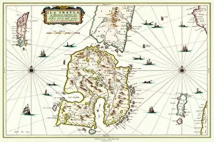
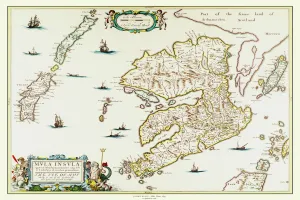
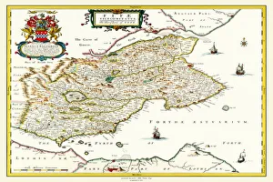
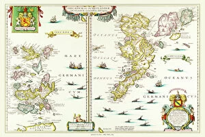
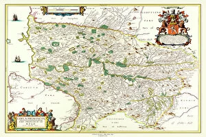
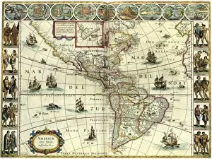
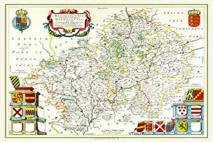
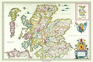
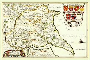
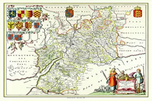
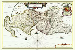
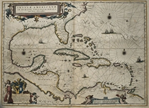
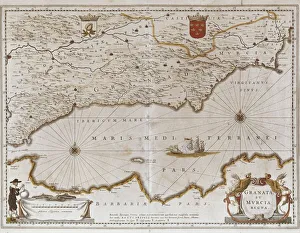
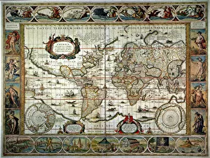
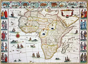
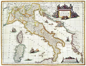
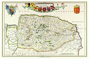
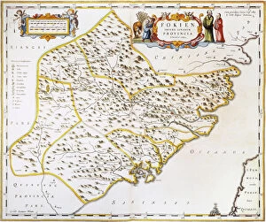
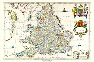
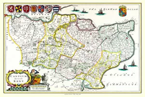
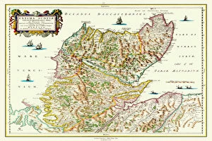
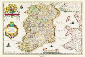
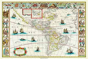
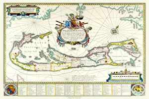
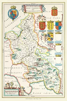
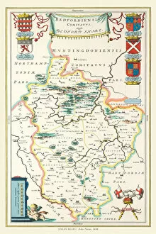
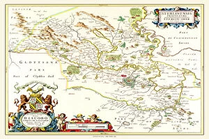
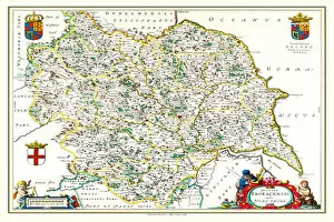
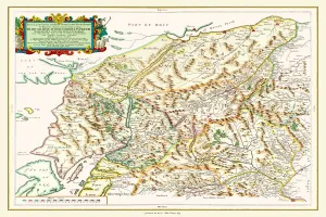
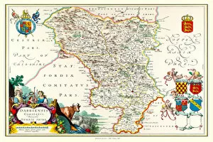
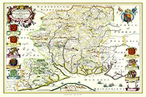
Discover the rich history and intricate details of ancient maps with Johan Blaeu's masterpieces. From the Old Map of the Isle of Islay Scotland in 1654 to the Old County Map of Surrey in 1648, Blaeu's Atlas Novus takes us on a captivating journey through time. Immerse yourself in the beauty of his cartographic artistry as you explore the Isles of Shetland and Orkney, or delve into the enchanting landscapes depicted in his Old Map of Wales. Travel back to a bygone era with Blaeu's meticulously crafted maps, such as the Old County Map of Gloucestershire or Kyle and Mid Ayrshire. Marvel at his collaboration with Willem Blaeu on Theatrum Orbis Terrarum, showcasing an exquisite map of Scotland from 1635. And don't miss out on exploring North and South America through their eyes with their remarkable creation dating back to c1630. Let these historic treasures transport you to distant lands and ignite your curiosity for exploration.