Fraud Blocker Skip to main content

Boundary Collection

"Exploring Boundaries

Background imageBoundary Collection: Sycamore (Acer pseudoplatanus) in Sycamore Gap, Hadrians Wall

Sycamore (Acer pseudoplatanus) in Sycamore Gap, Hadrians Wall. The wall is constructed on The Whin Sill, a layer of hard intrusive, volcanic Dolerite

Background imageBoundary Collection: Boundary Park Art - Oldham Athletic

Boundary Park Art - Oldham Athletic
Watercolour of Boundary Park, home of Oldham Athletic F.C. 1904 - current day. Capacity 10, 638. Original Painting size 20" x 16" created in 1999 by Kevin Fletcher

Background imageBoundary Collection: Ancient and Modern Jerusalem Map Engraving

Ancient and Modern Jerusalem Map Engraving
Engraved illustration of Ancient and Modern Jerusalem Map Engraving from The Popular Pictorial Bible, Containing the Old and New Testaments, Published in 1862. Copyright has expired on this artwork

Background imageBoundary Collection: MAP OF MACEDONIAN EMPIRE. Map of the Macedonian Empire following the conquests of Alexander

MAP OF MACEDONIAN EMPIRE. Map of the Macedonian Empire following the conquests of Alexander the Great, 4th century B.C

Background imageBoundary Collection: Map of the Word with lines marking boundaries of tectonic plates

Map of the Word with lines marking boundaries of tectonic plates

Background imageBoundary Collection: Travels of The Apostle Paul Map Engraving

Travels of The Apostle Paul Map Engraving
Engraved illustration of the Travels of The Apostle Paul Map Engraving from The Popular Pictorial Bible, Containing the Old and New Testaments, Published in 1862

Background imageBoundary Collection: Africa Political Map

Africa Political Map
Antique illustration of a Africa Political Map from 1893

Background imageBoundary Collection: Scotland, UK, satellite image

Scotland, UK, satellite image
Scotland, UK. North is at top. Natural colour satellite image showing Scotland in the United Kingdom, with the surrounding territories shaded out

Background imageBoundary Collection: London arms and seals

London arms and seals
The Arms and Common Seals of the Metropolitan Boroughs of London and of the City of London, with a block map showing their boundaries

Background imageBoundary Collection: RF - Lions (Panthera leo) - two brothers patrolling territorial boundary

RF - Lions (Panthera leo) - two brothers patrolling territorial boundary. Short grass plains on the border of Serengeti / Ngorongoro Conservation Area (NCA) near Ndutu, Tanzania

Background imageBoundary Collection: Earths tectonic plates

Earths tectonic plates. Global map showing the boundaries of the tectonic plates that make up the Earths crust. The eight major plates are the: African Plate, Antarctic Plate, Indian Plate

Background imageBoundary Collection: Middlesex Fire Brigade in the London Fire Brigade area

Middlesex Fire Brigade in the London Fire Brigade area
Mutual assistance took place where a nearby fire brigade would attend a fire in the London Fire Brigade area, or vice-versa

Background imageBoundary Collection: U. S. territory gained from Mexico

U. S. territory gained from Mexico
Map of territory acquired by the U.S. from Mexico. Color lithograph of a 19th-century illustration

Background imageBoundary Collection: LCC-LFB Plumstead fire station, SE London

LCC-LFB Plumstead fire station, SE London
Situated in Plumstead High Street and opened in 1906, Plumstead fire station was one of the LCC boundary fire stations bordering onto the Kent Fire Brigade until 1965

Background imageBoundary Collection: Warwickshire Cricket Club - 1888

Warwickshire Cricket Club - 1888
Sketches at the County Ground, Edgbaston, Birmingham - the home of Warwickshire CC. The main pavilion is shown in the centre

Background imageBoundary Collection: Denis Compton at Hastings

Denis Compton at Hastings
Denis Compton turns a ball from spinner Jim Laker (out of picture) off his legs to score another boundary past the despairing reach of the short leg fielder as wicketkeeper Stewart Billy Griffith

Background imageBoundary Collection: Tewkesbury fromTewkesbury Abbey UK

Tewkesbury fromTewkesbury Abbey UK
Ashley Cooper / SpecialistStock

Background imageBoundary Collection: Growth of the United States to 1853

Growth of the United States to 1853
U.S. map, showing territorial growth to 1853. Printed color lithograph of a 19th-century illustration

Background imageBoundary Collection: Lions (Panthera leo) - two brothers patrolling territorial boundary, affectionate behaviour

Lions (Panthera leo) - two brothers patrolling territorial boundary, affectionate behaviour, border of Serengeti / Ngorongoro Conservation Area (NCA) near Ndutu, Tanzania

Background imageBoundary Collection: National Childrens Home (NCH), Alverstoke - Aerial view

National Childrens Home (NCH), Alverstoke - Aerial view
National Childrens Home (NCH), Alverstoke, Hampshire. Aerial view showing the boundary of the homes site. Date: July 1939

Background imageBoundary Collection: Illustration of tectonic plates moving past each other (transform boundary)

Illustration of tectonic plates moving past each other (transform boundary)

Background imageBoundary Collection: Illustration of tectonic plates moving apart (divergent boundary)

Illustration of tectonic plates moving apart (divergent boundary)

Background imageBoundary Collection: Illustration of tectonic plates moving together (convergent boundary), creating mountains

Illustration of tectonic plates moving together (convergent boundary), creating mountains

Background imageBoundary Collection: Aerial view of tulip fields in the Netherlands

Aerial view of tulip fields in the Netherlands

Background imageBoundary Collection: Map of Africa showing Treaty Boundaries, 1891 (colour lithograph)

Map of Africa showing Treaty Boundaries, 1891 (colour lithograph)
XCF282018 Map of Africa showing Treaty Boundaries, 1891 (colour lithograph) by English School, (19th century); British Museum, London, UK; English, out of copyright

Background imageBoundary Collection: Voyager probe trajectory, artwork C018 / 0285

Voyager probe trajectory, artwork C018 / 0285
Voyager probe trajectory, artwork. Artwork of the trajectory of one of the Voyager probes as it travels out of the solar system

Background imageBoundary Collection: An 1895 American cartoon by F. Victor Gillam suggesting that the Cleveland administration was

An 1895 American cartoon by F. Victor Gillam suggesting that the Cleveland administration was inattentive to British
VENEZUELA BOUNDARY, 1895. An 1895 American cartoon by F. Victor Gillam suggesting that the Cleveland administration was inattentive to British encroachment during the Venezuelan Boundary Dispute

Background imageBoundary Collection: US territorial acquisition during the 1800s

US territorial acquisition during the 1800s
Map showiing the territorial growth of the continental US 1776 to 1899. Hand-colored woodcut of a 19th-century illustration

Background imageBoundary Collection: Paris Commune

Paris Commune
Cobblestones ripped from the streets and used for barricades on the Quai Pelletier and the Pont d Arcole during the siege of the Paris Commune, during the Franco-Prussian War

Background imageBoundary Collection: Czech Republic, Prague, View of the citadel, color engraving from Civitates Orbis Terrarum by

Czech Republic, Prague, View of the citadel, color engraving from Civitates Orbis Terrarum by Georg Braun (1541-1622) and Franz Hogenberg (1535-1590) 16th-17th century

Background imageBoundary Collection: 1832 Victorian Map of Launceston

1832 Victorian Map of Launceston

Background imageBoundary Collection: The Milkmaid, 1902 (pencil and watercolour)

The Milkmaid, 1902 (pencil and watercolour)
652074 The Milkmaid, 1902 (pencil and watercolour) by Wilson, Charles Edward (1853-1941); 52.7x34.9 cm; Private Collection; (add.info.: The Milkmaid. Charles Edward Wilson (1854-1941)

Background imageBoundary Collection: A Peep at the Train, India, 1892 (pencil and w / c on paper)

A Peep at the Train, India, 1892 (pencil and w / c on paper)
1197524 A Peep at the Train, India, 1892 (pencil and w/c on paper) by Swoboda, Rudolf Der G. (1859-1914); 94x66.8 cm; Private Collection; Photo eChristies Images; Austrian, out of copyright

Background imageBoundary Collection: Woman walking through security gate, carrying bag, contents made visible

Woman walking through security gate, carrying bag, contents made visible

Background imageBoundary Collection: USA, WA, San Juan Islands. Turn Point Lighthouse on Stuart Island was built in 1893

USA, WA, San Juan Islands. Turn Point Lighthouse on Stuart Island was built in 1893. This duplex home housed the keeper and his family on one side, assistant keeper and his family on the other

Background imageBoundary Collection: CANADA: MAP, 1872. Map of the boundary between British and American territory on the Pacific coast

CANADA: MAP, 1872. Map of the boundary between British and American territory on the Pacific coast, settled by the decision of the Emperor of Germany by arbitration in 1872

Background imageBoundary Collection: Edward VII Memorial unveiling at Brighton and Hove

Edward VII Memorial unveiling at Brighton and Hove
The unveiling of a Memorial to the late King Edward VII on the boundary dividing the boroughs of Brighton and Hove. It was unveiled by the Lord Lieutenant of Sussex, the Duke of Norfolk

Background imageBoundary Collection: Africa / Exploration / Congo

Africa / Exploration / Congo
CONGO - French and German officials, determined to correctly map the boundary between their territories, make their way through the marshy Lobaye valley

Background imageBoundary Collection: Beside the Old Church Gate Farm, Smarden, Kent (watercolour with scratching out)

Beside the Old Church Gate Farm, Smarden, Kent (watercolour with scratching out)
1766697 Beside the Old Church Gate Farm, Smarden, Kent (watercolour with scratching out) by Allingham, Helen (1848-1926); 24.5x32.8 cm; Private Collection; (add.info)

Background imageBoundary Collection: A Grey Arab Stallion in a Wooded Landscape, (oil on canvas)

A Grey Arab Stallion in a Wooded Landscape, (oil on canvas)
652178 A Grey Arab Stallion in a Wooded Landscape, (oil on canvas) by Agasse, Jacques-Laurent (1767-1849); 88.9x113 cm; Private Collection; (add.info.: A Grey Arab Stallion in a Wooded Landscape)

Background imageBoundary Collection: Sketch map of proposed improvements, Birmingham

Sketch map of proposed improvements, Birmingham
Sketch map of a locality around Stafford Street in Birmingham with the proposed new street running through it. The boundary of the unhealthy area referred to in the Birmingham Improvement Scheme as

Background imageBoundary Collection: Italy, Tuscany, Lucca, map of Lucca, cartography

Italy, Tuscany, Lucca, map of Lucca, cartography 17th century, Archivio Di Stato (National Archives)

Background imageBoundary Collection: Barns and stone walls near Muker - Swaledale - Yorkshire Dales National Park - North Yorkshire

Barns and stone walls near Muker - Swaledale - Yorkshire Dales National Park - North Yorkshire
ROG-14417 Barns and stone walls near Muker - Swaledale - Yorkshire Dales National Park - North Yorkshire Bob Gibbons contact details: prints@ardea.com tel: +44 (0) 20 8318 1401

Background imageBoundary Collection: Demonstration to keep Horley and Charlwood in Surrey

Demonstration to keep Horley and Charlwood in Surrey
A group of people on a demonstration in the middle of a road, holding banners and placards, determined to keep Horley and Charlwood in Surrey

Background imageBoundary Collection: Events / Asia / Afghanistan

Events / Asia / Afghanistan
Tur Khum Gardens near Landikhana, showing the boundary line between Afghanistan and the North-West Frontier Province

Background imageBoundary Collection: The Afghan Boundary: Junction of the Murghab and Kushk Rivers, Ak-Tapa in the Distance

The Afghan Boundary: Junction of the Murghab and Kushk Rivers, Ak-Tapa in the Distance, 1885

Background imageBoundary Collection: Map of Italy, c.1900 (engraving)

Map of Italy, c.1900 (engraving)
532986 Map of Italy, c.1900 (engraving); (add.info.: Map of northern Italy, circa 1902, from the 10th edition of Encyclopaedia Britannica.); Encyclopaedia Britannica/UIG.

Background imageBoundary Collection: Map of Switzerland and Liechtenstein, c.1900 (engraving)

Map of Switzerland and Liechtenstein, c.1900 (engraving)
532974 Map of Switzerland and Liechtenstein, c.1900 (engraving); (add.info.: Map showing historical boundaries of Switzerland and Liechtenstein, circa 1902)


All Professionally Made to Order for Quick Shipping

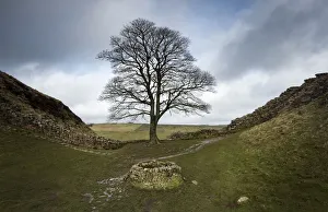
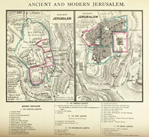
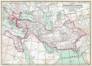
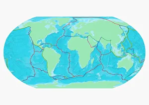
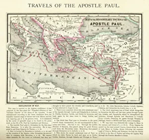
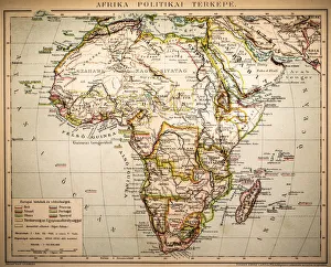
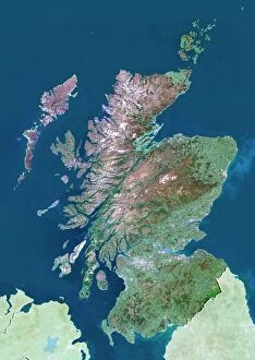
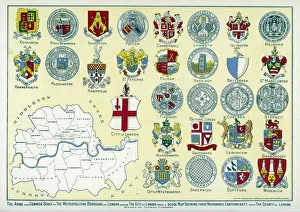
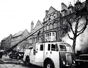
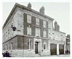
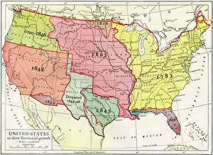
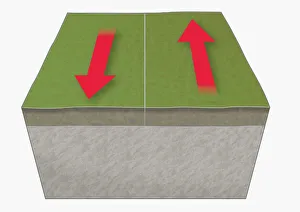
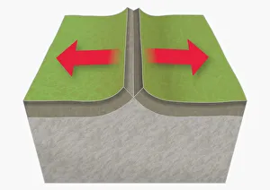
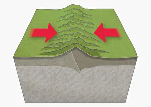
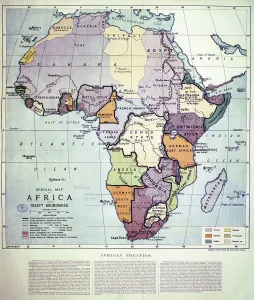
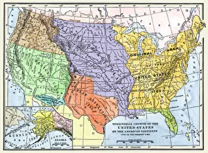
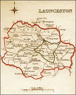
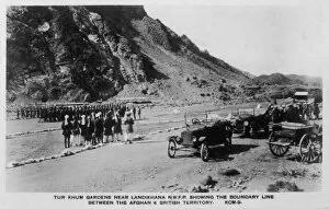
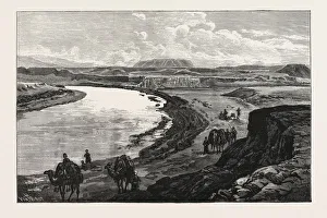
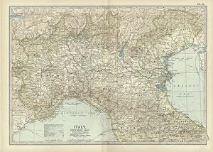
"Exploring Boundaries: From Ancient Empires to Modern Territories" This captivating collection of images highlights the significance and diversity of boundaries across various realms. Starting with Boundary Park Art in Oldham Athletic, we witness how art can transcend physical limits and connect communities. Moving on to Scotland, UK, a satellite image showcases the intricate lines that define national borders. Delving into history, we encounter the Map of the Macedonian Empire after Alexander the Great's conquests. This map symbolizes both territorial expansion and cultural exchange during one of history's most influential periods. Shifting our focus to geology, a Map of the World reveals lines marking tectonic plate boundaries—a reminder of Earth's ever-changing nature. In contrast, two majestic lions patrolling their territorial boundary remind us that animals too have distinct territories they fiercely protect. As we explore further, maps depicting The Apostle Paul's travels and ancient-modern Jerusalem offer glimpses into religious boundaries shaped by faith and historical events. Meanwhile, an Africa Political Map emphasizes geopolitical divisions shaping nations' identities today. Closer to home in London, arms and seals represent local authority while highlighting administrative boundaries within this bustling metropolis. Additionally, Earth’s tectonic plates illustrate how invisible forces shape our planet beneath its surface. Lastly, we reflect on U. S territory gained from Mexico—a testament to political negotiations defining international borders throughout history. Concluding with LCC-LFB Plumstead fire station in SE London signifies how even emergency services are organized based on geographical boundaries for efficient response times. In this diverse array of images lies a common thread—the concept of "boundary. " Whether physical or abstract; natural or man-made.